IMAGES TAKEN NEAR TO
Pentre Road, SWANSEA, SA4 8DA
Introduction
This page details the photographs taken nearby to Pentre Road, SA4 8DA by members of the Geograph project.
The Geograph project started in 2005 with the aim of publishing, organising and preserving representative images for every square kilometre of Great Britain, Ireland and the Isle of Man.

There are currently over 7.5m images from over14,400 individuals and you can help contribute to the project by visiting https://www.geograph.org.uk
Image Map (Loading...)


Getting Data...Please wait
Leaflet Map data © OpenStreetMap
Images are licensed for reuse under creativecommons.org/licenses/by-sa/2.0
Notes
- Clicking on the map will re-center to the selected point.
- The higher the marker number, the further away the image location is from the centre of the postcode.
Image Listing (16 Images Found)
Images are licensed for reuse under creativecommons.org/licenses/by-sa/2.0
Image
Details
Distance
1
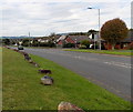
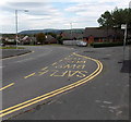
Boulder-lined B4296 Pentre Road Grovesend
Boulders protect the east side of a triangular green from the damage
that would be caused by the tyres of cars or lorries.
Image: © Jaggery
Taken: 29 Sep 2013
0.07 miles
2
Clos Pengelli, Grovesend
Clos Pengelli is a short cul-de-sac on the east side of B4296 Pentre Road.
Pengelli is the Welsh name for Grovesend.
Image: © Jaggery
Taken: 29 Sep 2013
0.07 miles
3
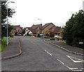
Grove Farm Road, Grovesend
Viewed from the corner of the B4296 Pentre Road.
Image: © Jaggery
Taken: 29 Sep 2013
0.09 miles
4
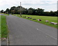
Boulder-lined Box Road Grovesend
Boulders protect the south side of a triangular green from the damage that would be caused by the tyres of cars or lorries.
Image: © Jaggery
Taken: 29 Sep 2013
0.10 miles
5
Bus stop near Station Road, Grovesend
The bus stop is alongside the B4296, which is named High Street on the south side of Station Road
and Pentre Road on the north side. The car is parked on the corner of Station Road.
The bus stop is on bus route 404 from Llanelli to Swansea. There were no buses today, a Sunday.
Image: © Jaggery
Taken: 29 Sep 2013
0.11 miles
6
Western end of Station Road Grovesend
Viewed from the corner of the B4296. Station Road formerly led to Pont Lliw railway station
about 600 metres to the east (ahead). Passenger services at Pont Lliw ceased in 1924.
Image: © Jaggery
Taken: 29 Sep 2013
0.11 miles
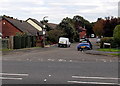
8
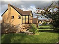
Grove Farm Road
Modern housing estate at Grovesend.
Image: © Alan Hughes
Taken: 5 Nov 2017
0.13 miles
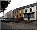
9
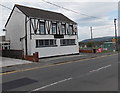
Bryn Lliw viewed from the south, Grovesend
Bryn Lliw is a bar and restaurant at 6 High Street, Grovesend.
Image: © Jaggery
Taken: 29 Sep 2013
0.14 miles
10
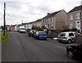
Station Road houses, Grovesend
Looking east along Station Road towards the site of the former Pont Lliw railway station, where passenger services ceased in 1924.
Image: © Jaggery
Taken: 29 Sep 2013
0.16 miles