IMAGES TAKEN NEAR TO
Napier Road, SWANSEA, SA4 8BW
Introduction
This page details the photographs taken nearby to Napier Road, SA4 8BW by members of the Geograph project.
The Geograph project started in 2005 with the aim of publishing, organising and preserving representative images for every square kilometre of Great Britain, Ireland and the Isle of Man.

There are currently over 7.5m images from over14,400 individuals and you can help contribute to the project by visiting https://www.geograph.org.uk
Image Map (Loading...)


Getting Data...Please wait
Leaflet Map data © OpenStreetMap
Images are licensed for reuse under creativecommons.org/licenses/by-sa/2.0
Notes
- Clicking on the map will re-center to the selected point.
- The higher the marker number, the further away the image location is from the centre of the postcode.
Image Listing (20 Images Found)
Images are licensed for reuse under creativecommons.org/licenses/by-sa/2.0
Image
Details
Distance
1
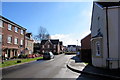
Towards Cwrt Rebecca from the corner of Heol Daniel, Pontarddulais
Viewed along Birch Rock Road in an area of houses built c2010 on the south side of the A48 Bolgoed Road.
Image: © Jaggery
Taken: 14 Feb 2015
0.07 miles
2

Bolgoed Road houses near Bolgoed Isaf Farm Pontarddulais
Along a side road leading to the farm. Viewed from the main course of Bolgoed Road (the A48).
Image: © Jaggery
Taken: 14 Feb 2015
0.13 miles
3
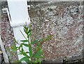
Ordnance Survey Cut Mark
This OS cut mark can be found on No90 Bolgoed Road. It marks a point 33.065m above mean sea level.
Image: © Adrian Dust
Taken: 7 Jul 2021
0.15 miles
4

Start of the 30 zone in the SE of Pontarddulais
The speed limit drops from 40mph to 30mph along the A48.
Image: © Jaggery
Taken: 14 Feb 2015
0.15 miles
5
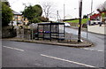
Junction bus shelter, bench and postbox in Pontarddulais
At the junction of the A48 Bolgoed Road and Goppa Road.
Image: © Jaggery
Taken: 11 Feb 2015
0.15 miles
6
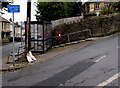
Unsuitable route for large vehicles,Goppa Road, Pontarddulais
The sign on the corner of the A48 Bolgoed Road leaves it to the driver to decide what height, weight, length and width equates to large.
Image: © Jaggery
Taken: 11 Feb 2015
0.15 miles
7
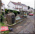
Boulder marking the location of a tollgate destroyed during the Rebecca Riots in Pontarddulais
Located alongside the A48 Bolgoed Road. The plaque on the boulder states that the Bolgoed Tollgate was destroyed on the 6th July 1843 by the Daughters of Rebecca led by Daniel Lewis.
The Rebecca Riots (1839-1843) in South and Mid Wales were a series of protests by local farmers and agricultural workers in response to perceived unfair taxation. The rioters (often men dressed as women) took their actions against tollgates which were tangible representations of high taxes and tolls.
Image: © Jaggery
Taken: 11 Feb 2015
0.15 miles
8
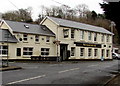
The Fountain Inn in Pontarddulais
At 111 Bolgoed Road at the SE edge of Pontarddulais.
Image: © Jaggery
Taken: 11 Feb 2015
0.15 miles
9

The Fountain Inn
Public house on the outskirts of Pontarddulais.
Image: © Alan Hughes
Taken: 19 Nov 2018
0.15 miles
10
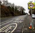
From 30 to 40 along Bolgoed Road, Pontarddulais
The speed limit increases to 40mph along the A48 Bolgoed Road near the SE edge of Pontarddulais.
Image: © Jaggery
Taken: 11 Feb 2015
0.15 miles