IMAGES TAKEN NEAR TO
Talsarn, LAMPETER, SA48 8QY
Introduction
This page details the photographs taken nearby to SA48 8QY by members of the Geograph project.
The Geograph project started in 2005 with the aim of publishing, organising and preserving representative images for every square kilometre of Great Britain, Ireland and the Isle of Man.

There are currently over 7.5m images from over14,400 individuals and you can help contribute to the project by visiting https://www.geograph.org.uk
Image Map (Loading...)


Getting Data...Please wait
Leaflet Map data © OpenStreetMap
Images are licensed for reuse under creativecommons.org/licenses/by-sa/2.0
Notes
- Clicking on the map will re-center to the selected point.
- The higher the marker number, the further away the image location is from the centre of the postcode.
Image Listing (16 Images Found)
Images are licensed for reuse under creativecommons.org/licenses/by-sa/2.0
Image
Details
Distance
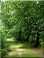
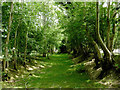
1

Byway to Brynog north-west of Tal-sarn, Ceredigion
This route is now designated as a restricted by-way (not for use by mechanically propelled vehicles).
Image: © Roger D Kidd
Taken: 23 Jul 2013
0.11 miles
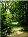
2
Byway to Brynog north-west of Tal-sarn, Ceredigion
Looking north-west.
This route is now designated as a restricted by-way (not for use by mechanically propelled vehicles).
Image: © Roger D Kidd
Taken: 23 Jul 2013
0.11 miles
3
Byway to Brynog north-west of Tal-sarn, Ceredigion
Looking north-west.
This route is now designated as a restricted by-way (not for use by mechanically propelled vehicles).
Image: © Roger D Kidd
Taken: 23 Jul 2013
0.11 miles
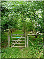
4
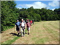
Tuat at / Towards Talsarn
Cerddwyr yn dilyn llwybr cyhoeddus i bentre Talsarn.
Walkers following a public footpath in the direction of Talsarn Village (trans. causeway end).
Image: © Alan Richards
Taken: 20 Jun 2010
0.13 miles
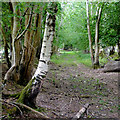
5
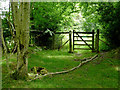
Green Lane towards Tal-sarn in Ceredigion
Looking south-east.
The unsurfaced route from Brynog is classified as a restricted by-way (not for use by mechanically propelled vehicles).
Image: © Roger D Kidd
Taken: 23 Jul 2013
0.13 miles
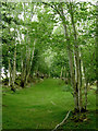
6
Byway to Tal-sarn in Ceredigion
Looking south-east.
The unsurfaced route from Brynog is classified as a restricted by-way (not for use by mechanically propelled vehicles).
Image: © Roger D Kidd
Taken: 23 Jul 2013
0.13 miles
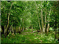
7
Green Lane towards Brynog in Ceredigion
Looking north-west.
This route is now designated as a restricted by-way (not for use by mechanically propelled vehicles).
Image: © Roger D Kidd
Taken: 23 Jul 2013
0.15 miles
8
Byway to Tal-sarn in Ceredigion
Looking south-east.
The unsurfaced route from Brynog is classified as a restricted by-way (not for use by mechanically propelled vehicles).
Image: © Roger D Kidd
Taken: 23 Jul 2013
0.18 miles
9
Green Lane towards Brynog in Ceredigion
Looking north-west.
This route is now designated as a restricted by-way (not for use by mechanically propelled vehicles).
Image: © Roger D Kidd
Taken: 23 Jul 2013
0.18 miles
10
Byway to Brynog in Ceredigion
Looking north-west.
This route between Tal-sarn and Brynog is now designated as a restricted by-way (not for use by mechanically propelled vehicles).
Image: © Roger D Kidd
Taken: 23 Jul 2013
0.18 miles