IMAGES TAKEN NEAR TO
Heol Hathren, LAMPETER, SA48 8JR
Introduction
This page details the photographs taken nearby to Heol Hathren, SA48 8JR by members of the Geograph project.
The Geograph project started in 2005 with the aim of publishing, organising and preserving representative images for every square kilometre of Great Britain, Ireland and the Isle of Man.

There are currently over 7.5m images from over14,400 individuals and you can help contribute to the project by visiting https://www.geograph.org.uk
Image Map (Loading...)


Getting Data...Please wait
Leaflet Map data © OpenStreetMap
Images are licensed for reuse under creativecommons.org/licenses/by-sa/2.0
Notes
- Clicking on the map will re-center to the selected point.
- The higher the marker number, the further away the image location is from the centre of the postcode.
Image Listing (9 Images Found)
Images are licensed for reuse under creativecommons.org/licenses/by-sa/2.0
Image
Details
Distance
1
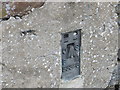
Ordnance Survey Flush Bracket G3328
This can be found on the wall of a building in Cwmann.
For more detail see : http://www.bench-marks.org.uk/bm15385
Image: © Peter Wood
Taken: 24 Apr 2015
0.06 miles
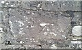
2
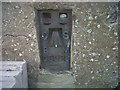
OSBM Flush Bracket G3328 - Cwmann, Post-gwyn
Ordnance Survey Benchmark (OSBM) used for levelling height above Ordnance Datum (OD).
Height (1955): 139.2951m OD (Newlyn). Mark verified by the Ordnance Survey in 1972. Description: FL BR G3328 BLDG POST GWYN SW SIDE RD NW FACE. 0.5m above ground. 1st Order BM.
The bracket was used on the Lampeter to Llandovery line (G098) of the Third Geodetic Levelling of England & Wales in 1955. Description: NW face of outbuilding at Postgwyn, SW side of road. Abstract G 65: http://discovery.nationalarchives.gov.uk/SearchUI/details?Uri=C11264473 [OS 54/754]
Context: Image
Image: © N Scott
Taken: 21 May 2012
0.07 miles
3
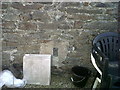
OSBM Flush Bracket G3328 - Cwmann, Post-gwyn
Ordnance Survey Benchmark (OSBM) used for levelling height above Ordnance Datum (OD).
Height (1955): 139.2951m OD (Newlyn). Mark verified by the Ordnance Survey in 1972. Description: FL BR G3328 BLDG POST GWYN SW SIDE RD NW FACE. 0.5m above ground. 1st Order BM.
The bracket was used on the Lampeter to Llandovery line (G098) of the Third Geodetic Levelling of England & Wales in 1955. Description: NW face of outbuilding at Postgwyn, SW side of road. Abstract G 65: http://discovery.nationalarchives.gov.uk/SearchUI/details?Uri=C11264473 [OS 54/754]
Close-up: Image
Image: © N Scott
Taken: 21 May 2012
0.07 miles
4
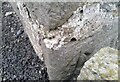
Ordnance Survey Cut Mark
This OS cut mark can be found on No21 Treherbert Street. It marks a point 147.450m above mean sea level.
Image: © Adrian Dust
Taken: 20 May 2021
0.15 miles
6
Ordnance Survey Cut Mark
This OS cut mark can be found on the NW parapet of Pont Hathren. It marks a point 119.878m above mean sea level.
Image: © Adrian Dust
Taken: 20 May 2021
0.23 miles
7
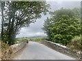
Lampeter, Wales.
Looking towards Lampeter town from the south-east
Image: © Nevin Arrow
Taken: 2 Aug 2003
0.23 miles
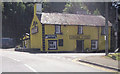
9
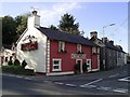
The Cwmanne Tavern
This 18th Century inn stands on the junction of the A482 to Pumsaint and the A485 to Llanybydder and is popular with university students and locals alike.
Image: © Dan Gregory
Taken: 3 Oct 2006
0.25 miles