IMAGES TAKEN NEAR TO
Cwmann, LAMPETER, SA48 8DR
Introduction
This page details the photographs taken nearby to SA48 8DR by members of the Geograph project.
The Geograph project started in 2005 with the aim of publishing, organising and preserving representative images for every square kilometre of Great Britain, Ireland and the Isle of Man.

There are currently over 7.5m images from over14,400 individuals and you can help contribute to the project by visiting https://www.geograph.org.uk
Image Map
Images are licensed for reuse under creativecommons.org/licenses/by-sa/2.0
Notes
- Clicking on the map will re-center to the selected point.
- The higher the marker number, the further away the image location is from the centre of the postcode.
Image Listing (57 Images Found)
Images are licensed for reuse under creativecommons.org/licenses/by-sa/2.0
Image
Details
Distance
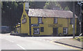
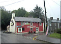
1
The Cwmanne Tavern
This 18th Century inn stands on the junction of the A482 to Pumsaint and the A485 to Llanybydder and is popular with university students and locals alike.
Image: © Dan Gregory
Taken: 3 Oct 2006
0.00 miles
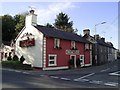
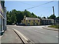
2
Cwmanne Tavern, Cwmann, Carmarthenshire
The A485 side of the pub on the corner of the A482. Cwmanne is a variant (perhaps an older, now disused, version) of Cwmann, the name shown on the village boundary sign. https://www.geograph.org.uk/photo/6176933 Cwmanne Tavern's appearance in June 2019 contrasts with this https://www.geograph.org.uk/photo/2663517 view in 2011.
Image: © Jaggery
Taken: 8 Jun 2019
0.01 miles
3
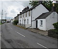
Houses alongside the A485, Cwmann, Carmarthenshire
On the approach to the A482 junction.
Image: © Jaggery
Taken: 8 Jun 2019
0.01 miles
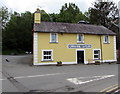
4
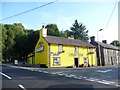
The Cwmanne Tavern
A colourful roadside inn and apparently steeped in history, this pub was established as a 16th century inn built on a former drovers road.
Image: © Jeremy Bolwell
Taken: 10 Aug 2012
0.01 miles
6
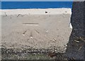
Ordnance Survey Cut Mark
This OS cut mark can be found on the NE face of the Cwmanne Tavern. It marks a point 115.838m above mean sea level.
Image: © Adrian Dust
Taken: 27 Aug 2017
0.01 miles
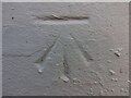
8

Ordnance Survey Benchmark - Cwmann Tavern
Ordnance Survey Benchmark (OSBM) used for levelling height above Ordnance Datum (OD).
Height: 115.838m OD (Newlyn). Mark verified by the Ordnance Survey in 1972. Description: CWM ANN TAVERN NE FACE N ANG. 0.3m above ground. 3rd Order BM.
Close-up: Image
Image: © N Scott
Taken: 3 Jun 2023
0.01 miles
9
Ordnance Survey Benchmark - Cwmann Tavern
Ordnance Survey Benchmark (OSBM) used for levelling height above Ordnance Datum (OD).
Height: 115.838m OD (Newlyn). Mark verified by the Ordnance Survey in 1972. Description: CWM ANN TAVERN NE FACE N ANG. 0.3m above ground. 3rd Order BM.
Context: Image
Image: © N Scott
Taken: 3 Jun 2023
0.01 miles