IMAGES TAKEN NEAR TO
LAMPETER, SA48 7RZ
Introduction
This page details the photographs taken nearby to SA48 7RZ by members of the Geograph project.
The Geograph project started in 2005 with the aim of publishing, organising and preserving representative images for every square kilometre of Great Britain, Ireland and the Isle of Man.

There are currently over 7.5m images from over14,400 individuals and you can help contribute to the project by visiting https://www.geograph.org.uk
Image Map (14 Images)


Getting Data...Please wait
Leaflet Map data © OpenStreetMap
Images are licensed for reuse under creativecommons.org/licenses/by-sa/2.0
Notes
- Clicking on the map will re-center to the selected point.
- The higher the marker number, the further away the image location is from the centre of the postcode.
Image Listing (14 Images Found)
Images are licensed for reuse under creativecommons.org/licenses/by-sa/2.0
Image
Details
Distance
1
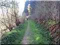
Llwybr ger Coed Ty-hen / Path near Ty-Hen Woods
Llwybr cyhoeddus ger Coed Ty-hen.
A public footpath near Ty-hen (trans. old house) woods.
Image: © Alan Richards
Taken: 21 Apr 2019
0.05 miles
2
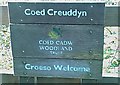
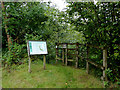
Arwydd Coed Creuddyn Sign
Coed Creuddyn wrth ochr y lon i Gwmhebog (Falcondale), tu fas i Lanbedr Pont Steffan (Llambed) ar yr heol i Aberaeron. Un o goedwigoedd Coed Cadw. Mae 'na lwybr cyhoeddus yn mynd drwodd
Golygfa cyfagos http://www.geograph.org.uk/photo/1258600.
Coed Creuddyn by Falcondale entrance, just outside Llanbedr Pont Steffan (Lampeter, Llambed) on the Aberaeron road. One of Woodland Trust's Woodlands, with public path running through it.
View nearby http://www.geograph.org.uk/photo/1258600.
Image: © G Williams
Taken: 26 Sep 2008
0.13 miles
3
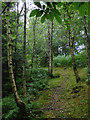
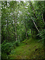
Woodland track north-west of Lampeter, Ceredigion
This track is in the Woodland Trust site at Coed Creuddyn close to the long lay-by on the A482.
Image: © Roger D Kidd
Taken: 14 Aug 2015
0.13 miles
4
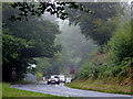
The A482 near Lampeter, Ceredigion
A telephoto assisted image looking towards Aberaeron on a dull wet August morning.
Image: © Roger D Kidd
Taken: 14 Aug 2015
0.14 miles
5
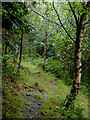
Woodland track north-west of Lampeter, Ceredigion
This track is in the Woodland Trust site at Coed Creuddyn close to the long lay-by on the A482.
http://www.woodlandtrust.org.uk/
Image: © Roger D Kidd
Taken: 14 Aug 2015
0.14 miles
6
Woodland track north-west of Lampeter, Ceredigion
This track is in the Woodland Trust site at Coed Creuddyn close to the long lay-by on the A482.
Image: © Roger D Kidd
Taken: 14 Aug 2015
0.14 miles
7
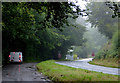
Lay-by and A482 north-west of Lampeter, Ceredigion
Looking towards Aberaeron some of the former road meanders are now as lay-bys, seen here on a dull wet morning! A small Woodland Trust site can be conveniently entered from this lay-by.
Image: © Roger D Kidd
Taken: 14 Aug 2015
0.14 miles
8
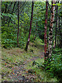
Woodland track north-west of Lampeter, Ceredigion
This track is in the Woodland Trust site at Coed Creuddyn close to the long lay-by on the A482.
Image: © Roger D Kidd
Taken: 14 Aug 2015
0.14 miles
9
Woodland north-west of Lampeter, Ceredigion
This entrance to the Woodland Trust site at Coed Creuddyn is from the large lay-by on the A482.
Image: © Roger D Kidd
Taken: 14 Aug 2015
0.14 miles
10
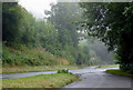
The A482 near Lampeter, Ceredigion
Looking towards Lampeter (Llanbedr Pont Steffan) some of the former road meanders are now as lay-bys, seen here on a dull wet morning!
Image: © Roger D Kidd
Taken: 14 Aug 2015
0.15 miles