IMAGES TAKEN NEAR TO
Ciliau Aeron, LAMPETER, SA48 7RE
Introduction
This page details the photographs taken nearby to SA48 7RE by members of the Geograph project.
The Geograph project started in 2005 with the aim of publishing, organising and preserving representative images for every square kilometre of Great Britain, Ireland and the Isle of Man.

There are currently over 7.5m images from over14,400 individuals and you can help contribute to the project by visiting https://www.geograph.org.uk
Image Map (Loading...)


Getting Data...Please wait
Leaflet Map data © OpenStreetMap
Images are licensed for reuse under creativecommons.org/licenses/by-sa/2.0
Notes
- Clicking on the map will re-center to the selected point.
- The higher the marker number, the further away the image location is from the centre of the postcode.
Image Listing (4 Images Found)
Images are licensed for reuse under creativecommons.org/licenses/by-sa/2.0
Image
Details
Distance
2
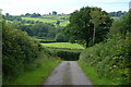
Minor road descending towards the Aeron valley
Heading for Neuadd-Lwyd.
Image: © Nigel Brown
Taken: 23 Jul 2010
0.19 miles
3
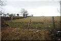
Farmland near Blaenpant
Looking uphill from a minor road junction.
Image: © Bob Jones
Taken: 27 Mar 2008
0.21 miles
4
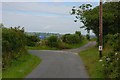
Road junction near Blaenpant
The main route swings left and is also a cycle route. The minor route straight ahead heads for Neuadd-lwyd.
Image: © Nigel Brown
Taken: 23 Jul 2010
0.23 miles