IMAGES TAKEN NEAR TO
New Street, LAMPETER, SA48 7AJ
Introduction
This page details the photographs taken nearby to New Street, SA48 7AJ by members of the Geograph project.
The Geograph project started in 2005 with the aim of publishing, organising and preserving representative images for every square kilometre of Great Britain, Ireland and the Isle of Man.

There are currently over 7.5m images from over14,400 individuals and you can help contribute to the project by visiting https://www.geograph.org.uk
Image Map
Images are licensed for reuse under creativecommons.org/licenses/by-sa/2.0
Notes
- Clicking on the map will re-center to the selected point.
- The higher the marker number, the further away the image location is from the centre of the postcode.
Image Listing (311 Images Found)
Images are licensed for reuse under creativecommons.org/licenses/by-sa/2.0
Image
Details
Distance
1
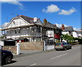
New Street scaffolding, Lampeter
Viewed on May 11th 2019.
Image: © Jaggery
Taken: 11 May 2019
0.02 miles
3
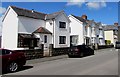
White houses, New Street, Lampeter
This part of New Street is between Cae Dash and Teifi Terrace.
Image: © Jaggery
Taken: 11 May 2019
0.03 miles
4
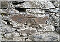
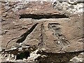
Ordnance Survey Cut Mark
This OS cut mark can be found on the wall of Delville, New Street. It marks a point 120.840m above mean sea level.
Image: © Adrian Dust
Taken: 20 May 2021
0.03 miles
5
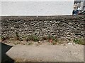
Ordnance Survey Benchmark - Lampeter, Delville
Ordnance Survey Benchmark (OSBM) used for levelling height above Ordnance Datum (OD).
Height: 120.8400m OD (Newlyn). Mark verified by the Ordnance Survey in 1972. Description: WALL DELVILLE 3M ANG WALL SE FACE. 0.4m above ground. 3rd Order BM.
Context: Image
Image: © N Scott
Taken: 3 Jun 2023
0.03 miles
6
Ordnance Survey Benchmark - Lampeter, Delville
Ordnance Survey Benchmark (OSBM) used for levelling height above Ordnance Datum (OD).
Height: 120.8400m OD (Newlyn). Mark verified by the Ordnance Survey in 1972. Description: WALL DELVILLE 3M ANG WALL SE FACE. 0.4m above ground. 3rd Order BM.
Close-up: Image
Image: © N Scott
Taken: 3 Jun 2023
0.03 miles
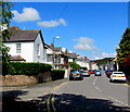
7
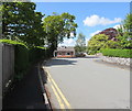
Bend in New Street, Lampeter
New Street bends to the right at the Cae Dash junction.
Image: © Jaggery
Taken: 11 May 2019
0.05 miles
8
Toiledau/Toilets direction sign, New Street, Lampeter
The Welsh/English sign is on a lamppost near the Cae Dash junction.
Image: © Jaggery
Taken: 11 May 2019
0.05 miles
9
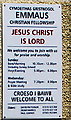
Emmaus Christian Fellowship information board, Lampeter
On the wall near the door here. https://www.geograph.org.uk/photo/6152202
Emmaus Christian Fellowship is
Cymdeithas Gristnogol Emmaus in Welsh.
Image: © Jaggery
Taken: 11 May 2019
0.05 miles
10
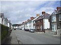
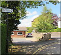
New Street, Lampeter
Looking to the NNW along New Street from the corner of Cae Dash.
Image: © Jaggery
Taken: 11 May 2019
0.06 miles