IMAGES TAKEN NEAR TO
Culfor Road, SWANSEA, SA4 6TY
Introduction
This page details the photographs taken nearby to Culfor Road, SA4 6TY by members of the Geograph project.
The Geograph project started in 2005 with the aim of publishing, organising and preserving representative images for every square kilometre of Great Britain, Ireland and the Isle of Man.

There are currently over 7.5m images from over14,400 individuals and you can help contribute to the project by visiting https://www.geograph.org.uk
Image Map
Images are licensed for reuse under creativecommons.org/licenses/by-sa/2.0
Notes
- Clicking on the map will re-center to the selected point.
- The higher the marker number, the further away the image location is from the centre of the postcode.
Image Listing (51 Images Found)
Images are licensed for reuse under creativecommons.org/licenses/by-sa/2.0
Image
Details
Distance
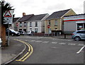
1
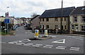
Culfor Road, Loughor
Culfor Road heads SE away from the A4240. This junction is where
the A4240 Glebe Road on the left becomes the A4240 Castle Street on the right.
Image: © Jaggery
Taken: 25 Mar 2016
0.02 miles
2
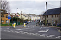
Culfor Road, Loughor
A residential road, but it is a useful cut through towards Gowerton.
Image: © Bill Boaden
Taken: 6 Apr 2016
0.04 miles
3
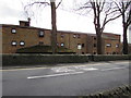
Llys-y-Coed Sheltered Complex, Loughor
Viewed across Glebe Road. Managed by a resident warden,
Llys-y-Coed provides sheltered housing for people aged at least 60.
Image: © Jaggery
Taken: 25 Mar 2016
0.05 miles
4
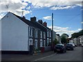
Culfor Road
Houses in Culfor road, Loughor.
Image: © Alan Hughes
Taken: 21 May 2019
0.06 miles
5
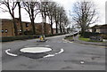
Mini-roundabout, Glebe Road, Loughor
On the A4240 Glebe Road at the Glanymor Park Drive junction.
Image: © Jaggery
Taken: 25 Mar 2016
0.07 miles
6
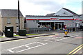
Spar shop, Loughor
At 1-3 Castle Street, on the corner of Culfor Road.
Image: © Jaggery
Taken: 25 Mar 2016
0.08 miles
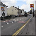
7
Warning sign - humps to the right and left, Loughor
Showing (speed) hump to the left 120 yds and humps to the right for 350 yds,
the sign faces The Croft at the A4240 Castle Street junction.
Image: © Jaggery
Taken: 25 Mar 2016
0.08 miles
8
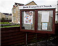
Jireh Evangelical Church information board, Loughor
Facing Castle Street 35 metres south of Jireh Evangelical Church http://www.geograph.org.uk/photo/4922990
Image: © Jaggery
Taken: 25 Mar 2016
0.09 miles
9
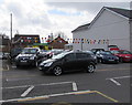
Castle Garages, Loughor
Car sales business and MOT test centre on the south side of the A4240 Castle Street.
Image: © Jaggery
Taken: 25 Mar 2016
0.09 miles
10
Warning signs - School/Ysgol, Castle Street, Loughor
On the approach to Casllwchwr Primary School. http://www.geograph.org.uk/photo/4923060
Image: © Jaggery
Taken: 25 Mar 2016
0.09 miles