IMAGES TAKEN NEAR TO
Dock Street, SWANSEA, SA4 6TP
Introduction
This page details the photographs taken nearby to Dock Street, SA4 6TP by members of the Geograph project.
The Geograph project started in 2005 with the aim of publishing, organising and preserving representative images for every square kilometre of Great Britain, Ireland and the Isle of Man.

There are currently over 7.5m images from over14,400 individuals and you can help contribute to the project by visiting https://www.geograph.org.uk
Image Map (Loading...)


Getting Data...Please wait
Leaflet Map data © OpenStreetMap
Images are licensed for reuse under creativecommons.org/licenses/by-sa/2.0
Notes
- Clicking on the map will re-center to the selected point.
- The higher the marker number, the further away the image location is from the centre of the postcode.
Image Listing (94 Images Found)
Images are licensed for reuse under creativecommons.org/licenses/by-sa/2.0
Image
Details
Distance
1
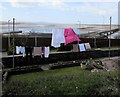
Washing on lines above the Loughor Estuary
Viewed from St Michael's churchyard in Loughor. http://www.geograph.org.uk/photo/4925213
Image: © Jaggery
Taken: 25 Mar 2016
0.01 miles
2
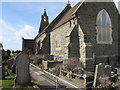
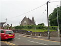
South side of St Michael's Church, Loughor
Located above the Loughor Estuary, St Michael's Church is in the Church
in Wales Parish of Loughor in the Diocese of Swansea and Brecon.
Image: © Jaggery
Taken: 25 Mar 2016
0.01 miles
3
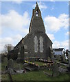
West side of St Michael's Church, Loughor
Located above the Loughor Estuary, St Michael's Church is in the Church
in Wales Parish of Loughor in the Diocese of Swansea and Brecon.
Image: © Jaggery
Taken: 25 Mar 2016
0.02 miles
4
East side of St Michael's Church, Loughor
Viewed across Station Road.
St Michael's Church is in the Church in Wales Parish of Loughor in the Diocese of Swansea and Brecon
Image: © Jaggery
Taken: 25 Mar 2016
0.02 miles
5
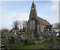
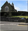
St Michael's Church and churchyard, Loughor
Located above the Loughor Estuary, St Michael's Church is in the Church
in Wales Parish of Loughor in the Diocese of Swansea and Brecon.
Image: © Jaggery
Taken: 25 Mar 2016
0.02 miles
6
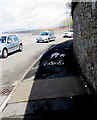
Cycle route and pavement, Castle Street, Loughor
Part of National Cycle Network Route 4 from London to Fishguard via Reading, Bath, Bristol, Newport, Swansea, Llanelli and St Davids. Here in Wales, the route is one of the branches of the Celtic Trail cycle route.
Image: © Jaggery
Taken: 25 Mar 2016
0.03 miles
7
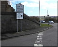
Welcome to the City & County of Swansea, Loughor
The bilingual sign alongside the A4240 shows that Swansea is Abertawe in Welsh.
Image: © Jaggery
Taken: 25 Mar 2016
0.03 miles
8
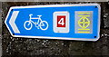
National Cycle Network Route 4 direction sign, Loughor
On a wall near this part https://www.geograph.org.uk/photo/6040928 of Route 4 from London to Fishguard.
Image: © Jaggery
Taken: 25 Mar 2016
0.03 miles
10
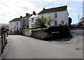
Station Road, Loughor
Viewed past the corner of Dock Street. This used to be the way to Loughor railway station which closed in 1960.
Image: © Jaggery
Taken: 25 Mar 2016
0.03 miles