IMAGES TAKEN NEAR TO
Aberarth, ABERAERON, SA46 0LT
Introduction
This page details the photographs taken nearby to SA46 0LT by members of the Geograph project.
The Geograph project started in 2005 with the aim of publishing, organising and preserving representative images for every square kilometre of Great Britain, Ireland and the Isle of Man.

There are currently over 7.5m images from over14,400 individuals and you can help contribute to the project by visiting https://www.geograph.org.uk
Image Map (Loading...)


Getting Data...Please wait
Leaflet Map data © OpenStreetMap
Images are licensed for reuse under creativecommons.org/licenses/by-sa/2.0
Notes
- Clicking on the map will re-center to the selected point.
- The higher the marker number, the further away the image location is from the centre of the postcode.
Image Listing (42 Images Found)
Images are licensed for reuse under creativecommons.org/licenses/by-sa/2.0
Image
Details
Distance
1
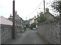
Aberarth, side street
There are two streets in Aberarth, on this side of the river . The other one is called Water Street.
Image: © Stuart Logan
Taken: 4 Oct 2011
0.01 miles
3
Neuadd Llanddewi Aberarth Hall
Looking rather like a larage garage, the village hall fulfils its purpose in Aberarth. The hall will seat 45 and there is a snooker room.
Image: © Eirian Evans
Taken: 24 Jun 2011
0.05 miles
4
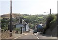
The coast path approaching Aberarth from the south
The coast path will probably need to be moved inland a bit here as the sea is undercutting these fields.
Image: © Jeremy Bolwell
Taken: 12 May 2011
0.05 miles
5
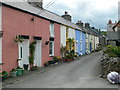
Pretty Water Street, Aberarth
Gaily painted houses and potted plants - painted cottages seem to be a feature of this area.
Image: © Eirian Evans
Taken: 24 Jun 2011
0.07 miles
6
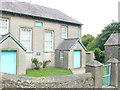
Bethel Welsh CM chapel, Aberarth
Built 1790, rebuilt 1805 & 1846, renewed 1900.
Image: © Eirian Evans
Taken: 24 Jun 2011
0.08 miles
7
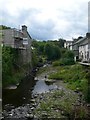
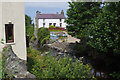
Afon Arth - Bear River
Emerging from the hills near Bethania, the river runs west for 15 miles before discharging into Cardigan Bay at Aberarth. Many buildings, including the chapel and the road bridge, were destroyed by floods in 1846.
Image: © Eirian Evans
Taken: 24 Jun 2011
0.08 miles
8
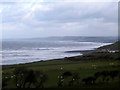
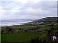
A stormy day over Cardigan Bay
With houses on the edge of Aberarth visible on the right and the Blaenpwll communication mast just visible across the bay.
Image: © John Lucas
Taken: 23 Feb 2002
0.08 miles
9
Afon Arth, Aberarth
The Afon Arth flows through the village on its way into Cardigan Bay.
Image: © Stephen McKay
Taken: 12 Jul 2015
0.08 miles
10
Aberarth
Viewed from the lay-by above Aberaeron.
Image: © John Lucas
Taken: 23 Feb 2002
0.09 miles