IMAGES TAKEN NEAR TO
Panteg Road, ABERAERON, SA46 0EQ
Introduction
This page details the photographs taken nearby to Panteg Road, SA46 0EQ by members of the Geograph project.
The Geograph project started in 2005 with the aim of publishing, organising and preserving representative images for every square kilometre of Great Britain, Ireland and the Isle of Man.

There are currently over 7.5m images from over14,400 individuals and you can help contribute to the project by visiting https://www.geograph.org.uk
Image Map
Images are licensed for reuse under creativecommons.org/licenses/by-sa/2.0
Notes
- Clicking on the map will re-center to the selected point.
- The higher the marker number, the further away the image location is from the centre of the postcode.
Image Listing (18 Images Found)
Images are licensed for reuse under creativecommons.org/licenses/by-sa/2.0
Image
Details
Distance
1
Arwydd heol A482 ar dollborth / A482 signpost on toll-gate
Arwydd stryd heol Llyswen ar fur siop "Southgate" (un o hen dollbyrth a newidwyd yn yr ardal) Aberaeron (Aberayron); a mynegbost cylchfan newydd Aberaeron hanner ffordd mas o olwg frig ochr dde.
Street sign for Lampeter road (Heol Llyswen-Whitecourt road) on the Aberaeron's (Aberayron) southgate shop (one of the converted toll-gates in the area) ; with the new roundabout's sign nearly out of sight up top right hand side.
Image: © G Williams
Taken: 25 Apr 2009
0.07 miles
3
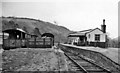
Aberayron station
View SE (away from buffers) of terminus of branch from Lampeter, seven years since closure to passengers, but still open for goods (and milk) until 5 April 1965.
Image: © Ben Brooksbank
Taken: 6 Apr 1958
0.11 miles
4
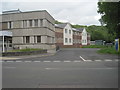
Aberayron railway station (site), Ceredigion
Opened in 1911 by the Lampeter Aberayron & New Quay Light Railway, later part of the Great Western Railway, as the terminus of the line from Lampeter (it never reached New Quay), this station closed to passengers in 1951 and completely in 1963. It always used the Anglicised name.
View south east from the road towards the site, which was later redeveloped. The single platform station was to the far right of the image, with sidings roughly where the buildings stand.
Image: © Nigel Thompson
Taken: 6 Jun 2017
0.13 miles
5
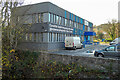
Aberaeron Integrated Care Centre
Beside Afon Aeron and built on the site of the Aberaeron railway branch terminus.
Image: © John Lucas
Taken: 30 Nov 2022
0.15 miles
6
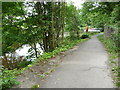
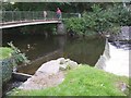
The weirs on the Afon Aeron in Aberaeron
A nice feature of a walk along this stretch of riverbank is the weirs busy with ducks.
Image: © Jeremy Bolwell
Taken: 12 May 2011
0.17 miles
7
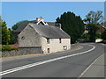
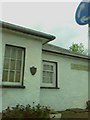
Cottage on South Road, on the outskirts of Aberaeron
This was the coach-house to Dolau Aeron, the large house to be seen behind it which was originally an inn. The cottage was built in the mid 18th century and is listed Grade II.
Image: © Eirian Evans
Taken: 13 Jul 2013
0.19 miles
8
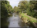
Afon Aeron, Aberaeron
The river after which the town is named, seen here looking downstream from Lovers' Bridge.
Image: © Humphrey Bolton
Taken: 30 Sep 2007
0.20 miles
9
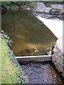
Weir on the Afon Aeron, Aberaeron
Presumably there was a mill here once, but now there is just a series of weirs.
Image: © Humphrey Bolton
Taken: 30 Sep 2007
0.20 miles
10
Lovers' Bridge, Aberaeron
I would guess that when this bridge was named it was a rustic wooden structure, which was probably swept away by a flood.
Image: © Humphrey Bolton
Taken: 30 Sep 2007
0.20 miles