IMAGES TAKEN NEAR TO
Alexandra Road, SWANSEA, SA4 4PE
Introduction
This page details the photographs taken nearby to Alexandra Road, SA4 4PE by members of the Geograph project.
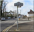
The Geograph project started in 2005 with the aim of publishing, organising and preserving representative images for every square kilometre of Great Britain, Ireland and the Isle of Man.

There are currently over 7.5m images from over14,400 individuals and you can help contribute to the project by visiting https://www.geograph.org.uk
Image Map
Images are licensed for reuse under creativecommons.org/licenses/by-sa/2.0
Notes
- Clicking on the map will re-center to the selected point.
- The higher the marker number, the further away the image location is from the centre of the postcode.
Image Listing (43 Images Found)
Images are licensed for reuse under creativecommons.org/licenses/by-sa/2.0
Image
Details
Distance
1
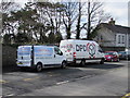
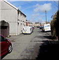
Vans in Alexandra Road, Loughor
Chris Farley Carpentry & Construction van and a DPD Global Express Parcels van.
Image: © Jaggery
Taken: 25 Mar 2016
0.01 miles
2
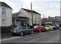
Leisure Launderette, Gorseinon
Launderette at 173 Alexandra Road.
Image: © Jaggery
Taken: 25 Mar 2016
0.03 miles
3
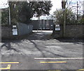
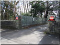
Entrance to the New Lodge, Gorseinon
Entrance only, from the A4240 Alexandra Road. The exit http://www.geograph.org.uk/photo/5001518 is to the east.
Image: © Jaggery
Taken: 25 Mar 2016
0.03 miles
4
Western boundary of Gorseinon
The Gorseinon boundary sign is on the corner of the A4240 Alexandra Road and Brynamlwg Road in Loughor. The Loughor boundary sign http://www.geograph.org.uk/photo/5001521 is on the back of the Gorseinon sign.
Image: © Jaggery
Taken: 25 Mar 2016
0.06 miles
5
Loughor/Casllwchwr boundary sign
The bilingual (English/Welsh) sign faces the A4240 Alexandra Road in Gorseinon at the eastern boundary of Loughor, a town in the City and County of Swansea, adjacent to Carmarthenshire.
The Gorseinon boundary sign http://www.geograph.org.uk/photo/5001546 is on the back of the Loughor sign.
Image: © Jaggery
Taken: 25 Mar 2016
0.06 miles
6
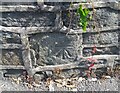
Ordnance Survey Cut Mark
This OS cut mark can be found on the wall of No132 Alexandra Road. It marks a point 33.165m above mean sea level.
Image: © Adrian Dust
Taken: 15 Jul 2021
0.06 miles
7
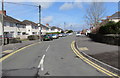
Cameron Place, Loughor
On the north side of Alexandra Road.
Image: © Jaggery
Taken: 25 Mar 2016
0.06 miles
8
Brynamlwg Road, Loughor
Looking north along Brynamlwg Road from near the A4240 Alexandra Road junction.
Image: © Jaggery
Taken: 25 Mar 2016
0.07 miles
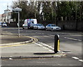
9
Exit road from the New Lodge, Gorseinon
Into the A4240 Alexandra Road.
Image: © Jaggery
Taken: 25 Mar 2016
0.09 miles
10
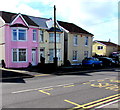
Pink house in Loughor
On the south side of Alexandra Road.
Image: © Jaggery
Taken: 25 Mar 2016
0.09 miles