IMAGES TAKEN NEAR TO
Ffordd Bryngwyn, SWANSEA, SA4 4EB
Introduction
This page details the photographs taken nearby to Ffordd Bryngwyn, SA4 4EB by members of the Geograph project.
The Geograph project started in 2005 with the aim of publishing, organising and preserving representative images for every square kilometre of Great Britain, Ireland and the Isle of Man.

There are currently over 7.5m images from over14,400 individuals and you can help contribute to the project by visiting https://www.geograph.org.uk
Image Map
Images are licensed for reuse under creativecommons.org/licenses/by-sa/2.0
Notes
- Clicking on the map will re-center to the selected point.
- The higher the marker number, the further away the image location is from the centre of the postcode.
Image Listing (12 Images Found)
Images are licensed for reuse under creativecommons.org/licenses/by-sa/2.0
Image
Details
Distance
1
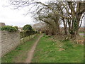
Llwybr Pentre Ardd / Garden Village Footpath
Llwybr Cyhoeddus yn arwain o Bentre Ardd at Gorseinon.
A public footpath going from Garden Village in the direction of Gorseinon (trans. Eynons' fen)
Image: © Alan Richards
Taken: 17 Mar 2014
0.09 miles
2
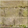
Ordnance Survey Cut Mark
This OS cut mark can be found on the north parapet of the railway bridge. It marks a point 19.166m above mean sea level.
Image: © Adrian Dust
Taken: 11 Feb 2022
0.11 miles
3
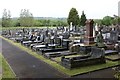
Kingsbridge Cemetery, Gorseinon Garden Village
Looking southwest from the cemetery wall on the Swansea Road. The cemetery dates back to the 1930s and was established on part of Stafford Common. It lies opposite Gorseinon Garden Village which dates back to 1913.
Image: © Simon Mortimer
Taken: 8 May 2018
0.13 miles
4
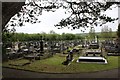
Kingsbridge Cemetery, Gorseinon Garden Village
Looking southeast from the cemetery wall on the Swansea Road. The cemetery dates back to the 1930s and was established on part of Stafford Common. It lies opposite Gorseinon Garden Village which dates back to 1913.
Image: © Simon Mortimer
Taken: 8 May 2018
0.13 miles
5
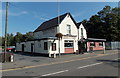
Tafarn-Y-Trap Kingsbridge
Pub in Swansea Road, Kingsbridge.
Image: © Jaggery
Taken: 29 Sep 2013
0.17 miles
7
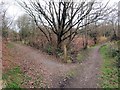
Cyffordd o lwybrau / Junction of paths
Cyffordd o lwybrau hanner ffordd rhwng Pentre Ardd a Gorseinon. Mae'r llwybr ar y chwith yn arwain at drac seiclo.
A junction of paths halfway between Garden Village and Gorseinon (trans. Eynon's fen). The path on the left joins the cycle track.
Image: © Alan Richards
Taken: 17 Mar 2014
0.18 miles
8
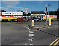
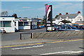
Yellow Star, Kingsbridge
Yellow Star Tradings Ltd is a commercial vehicle (new and used) business located in Kingsbridge Commercial Centre, Swansea Road, Kingsbridge.
Image: © Jaggery
Taken: 29 Sep 2013
0.19 miles
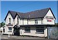
9
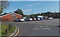
Garden Village AFC Sports & Social Club, Kingsbridge
The club building is located in the NW corner of the club's football ground in Stafford Common adjacent to Victoria Road Kingsbridge.
Image: © Jaggery
Taken: 29 Sep 2013
0.20 miles
10
Hair Kandi, Kingsbridge
Hairdressing salon viewed across Victoria Road.
Image: © Jaggery
Taken: 29 Sep 2013
0.24 miles