IMAGES TAKEN NEAR TO
Belgrave Close, SWANSEA, SA4 4BQ
Introduction
This page details the photographs taken nearby to Belgrave Close, SA4 4BQ by members of the Geograph project.
The Geograph project started in 2005 with the aim of publishing, organising and preserving representative images for every square kilometre of Great Britain, Ireland and the Isle of Man.

There are currently over 7.5m images from over14,400 individuals and you can help contribute to the project by visiting https://www.geograph.org.uk
Image Map (Loading...)


Getting Data...Please wait
Leaflet Map data © OpenStreetMap
Images are licensed for reuse under creativecommons.org/licenses/by-sa/2.0
Notes
- Clicking on the map will re-center to the selected point.
- The higher the marker number, the further away the image location is from the centre of the postcode.
Image Listing (38 Images Found)
Images are licensed for reuse under creativecommons.org/licenses/by-sa/2.0
Image
Details
Distance
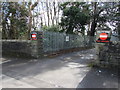
1
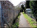
Public footpath south of Park Road, Gorseinon
Between the perimeter fence of Einon House http://www.geograph.org.uk/photo/5001121 on the left
and the perimeter fence of an ATC hut http://www.geograph.org.uk/photo/5001092 on the right.
Image: © Jaggery
Taken: 25 Mar 2016
0.13 miles
2
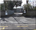
Entrance to the New Lodge, Gorseinon
Entrance only, from the A4240 Alexandra Road. The exit http://www.geograph.org.uk/photo/5001518 is to the east.
Image: © Jaggery
Taken: 25 Mar 2016
0.13 miles
3
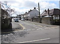
Danybryn Road, Loughor
On the south side of Alexandra Road.
Image: © Jaggery
Taken: 25 Mar 2016
0.14 miles
4
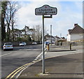
Loughor/Casllwchwr boundary sign
The bilingual (English/Welsh) sign faces the A4240 Alexandra Road in Gorseinon at the eastern boundary of Loughor, a town in the City and County of Swansea, adjacent to Carmarthenshire.
The Gorseinon boundary sign http://www.geograph.org.uk/photo/5001546 is on the back of the Loughor sign.
Image: © Jaggery
Taken: 25 Mar 2016
0.14 miles
5
Western boundary of Gorseinon
The Gorseinon boundary sign is on the corner of the A4240 Alexandra Road and Brynamlwg Road in Loughor. The Loughor boundary sign http://www.geograph.org.uk/photo/5001521 is on the back of the Gorseinon sign.
Image: © Jaggery
Taken: 25 Mar 2016
0.14 miles
6
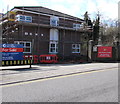
Einon House, Gorseinon
Viewed across Park Road in March 2016 when a For Sale notice is on display.
A wide entrance gate and barbed wire seen in a May 2011 Google Earth Street View have gone.
The sign on the right http://www.geograph.org.uk/photo/5001133 shows Army Reserve Centre and its Welsh equivalent.
Image: © Jaggery
Taken: 25 Mar 2016
0.15 miles
7
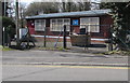
ATC hut, Park Road, Gorseinon
Opposite a bend in Park Road, near the A4240 Alexandra Road junction.
The name on the wall is AIR TRAINING CORPS 360 SQUADRON LLWCHWR.
Image: © Jaggery
Taken: 25 Mar 2016
0.15 miles
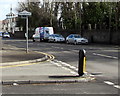
8

Vans in Alexandra Road, Loughor
Chris Farley Carpentry & Construction van and a DPD Global Express Parcels van.
Image: © Jaggery
Taken: 25 Mar 2016
0.15 miles
9
Exit road from the New Lodge, Gorseinon
Into the A4240 Alexandra Road.
Image: © Jaggery
Taken: 25 Mar 2016
0.15 miles
10
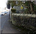
Western Power Distribution electricity substation behind a wall, Gorseinon
On the south side of the A4240 Alexandra Road near the Loughor boundary.
Image: © Jaggery
Taken: 25 Mar 2016
0.15 miles