IMAGES TAKEN NEAR TO
Penrhiwllan, LLANDYSUL, SA44 5NH
Introduction
This page details the photographs taken nearby to SA44 5NH by members of the Geograph project.
The Geograph project started in 2005 with the aim of publishing, organising and preserving representative images for every square kilometre of Great Britain, Ireland and the Isle of Man.

There are currently over 7.5m images from over14,400 individuals and you can help contribute to the project by visiting https://www.geograph.org.uk
Image Map (Loading...)


Getting Data...Please wait
Leaflet Map data © OpenStreetMap
Images are licensed for reuse under creativecommons.org/licenses/by-sa/2.0
Notes
- Clicking on the map will re-center to the selected point.
- The higher the marker number, the further away the image location is from the centre of the postcode.
Image Listing (4 Images Found)
Images are licensed for reuse under creativecommons.org/licenses/by-sa/2.0
Image
Details
Distance
1
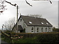
Llanfair Orllwyn
On my older edition of the Ordnance Survey map this house is marked by a cross indicating a religious building. I think it was the church hall as there is a church of the same name half a mile to the south. This building is now used as a dwelling house.
Image: © Marion Phillips
Taken: 20 Apr 2008
0.09 miles
2
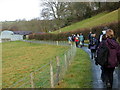
Tuag at Gwrycoed / Towards Cwrycoed
Cerddwyr yn dilyn llwybr ceffyl i gyfeiriad Ffarm Cwrycoed.
Walkers following a bridleway towards Cwrycoed Farm (trans. corner of the wood)
Image: © Alan Richards
Taken: 6 Jan 2008
0.19 miles
3
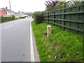
A475, Penrhiw-Llan
Standing beside the A475 is a milestone.
Milestones are the original roadside heritage features with many dating back hundreds of years and these historic items are under threat from highway developments.
Milestones did not come into general use until the Turnpike Act of 1766 made them compulsory on turnpike roads, these roads were built by private enterprise under licence from the Government and maintained by tolls on those who used them. Before this Act milestones were put up occasionally, often as charitable acts and commemorations. Many Turnpike Act stones still exist. They are usually 2-3 ft high, with the initial letter or abbreviation of the nearest market town show on two faces, and the distance from it.
Image: © Maigheach-gheal
Taken: 22 Sep 2010
0.22 miles
4
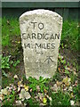
Milestone, Penrhiw-Llan
The milestone is beside the A475 and has an Ordnance Survey bench mark engraved into the face. For a wider view http://www.geograph.org.uk/photo/2086021 and for further information about the bench mark http://www.bench-marks.org.uk/bm35625
A bench mark is an Ordnance Survey arrowhead sign found on walls, bridges, churches and specially erected triangulation pillars where the altitude above sea-level has been accurately measured by surveyors. The arrowhead points to a horizontal line above it which marks the exact altitude.
With rivets and pivots there is no datum (horizontal line) cut, the pointed-to horizontal surface defining the datum height.
Image: © Maigheach-gheal
Taken: 22 Sep 2010
0.25 miles