IMAGES TAKEN NEAR TO
Sunny Hill, LLANDYSUL, SA44 4DX
Introduction
This page details the photographs taken nearby to Sunny Hill, SA44 4DX by members of the Geograph project.
The Geograph project started in 2005 with the aim of publishing, organising and preserving representative images for every square kilometre of Great Britain, Ireland and the Isle of Man.

There are currently over 7.5m images from over14,400 individuals and you can help contribute to the project by visiting https://www.geograph.org.uk
Image Map (Loading...)


Getting Data...Please wait
Leaflet Map data © OpenStreetMap
Images are licensed for reuse under creativecommons.org/licenses/by-sa/2.0
Notes
- Clicking on the map will re-center to the selected point.
- The higher the marker number, the further away the image location is from the centre of the postcode.
Image Listing (31 Images Found)
Images are licensed for reuse under creativecommons.org/licenses/by-sa/2.0
Image
Details
Distance
1
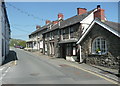
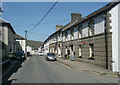
High Street, Llandysul
The last group of houses before leaving the town centre. The main street through the town centre is called Bridge Street, Wind Street, King Street and finally High Street, the latter presumably because it is at the top of the hill rather than more important.
Image: © Humphrey Bolton
Taken: 21 Apr 2019
0.04 miles
2
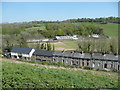
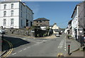
View from Lon Letty, Llandysul
The row of houses is on Church Street, and the view is from what was a lane but is now a wide road linking the top of High Street with Church Street.
Image: © Humphrey Bolton
Taken: 21 Apr 2019
0.07 miles
3
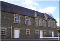
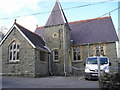
Old County Primary School
Now houses the Welsh Harp Centre.
Image: © Marion Phillips
Taken: 27 Mar 2008
0.10 miles
5
Porth Hotel, Church Street, Llandysul
Image: © Humphrey Bolton
Taken: 21 Apr 2019
0.11 miles
8
King Street and Richmond House, Llandysul
In 'The Buildings of Wales' Richmond House is described as "a surprisingly grand double villa in stucco of c.1870-80, more coastal resort than mid-Wales."
Image: © Humphrey Bolton
Taken: 21 Apr 2019
0.14 miles
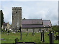
9
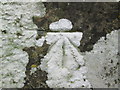
Ordnance Survey 1GL Bolt
This OS Bolt can be found on the west face of the tower of St Tyssul's Church. It marks a point 64.1065m above mean sea level.
Image: © Adrian Dust
Taken: 12 Mar 2015
0.14 miles
10
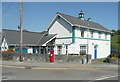
Council Offices, New Road, Llandysul
The single-storey wing to the left is the polices station. I missed Neuadd-Tysul-Hall, a performance and event venue built in 1955 in what I think is a modernist style evolved from Art Deco.
Image: © Humphrey Bolton
Taken: 21 Apr 2019
0.14 miles