IMAGES TAKEN NEAR TO
Durlais, SWANSEA, SA4 3RR
Introduction
This page details the photographs taken nearby to Durlais, SA4 3RR by members of the Geograph project.
The Geograph project started in 2005 with the aim of publishing, organising and preserving representative images for every square kilometre of Great Britain, Ireland and the Isle of Man.

There are currently over 7.5m images from over14,400 individuals and you can help contribute to the project by visiting https://www.geograph.org.uk
Image Map (Loading...)


Getting Data...Please wait
Leaflet Map data © OpenStreetMap
Images are licensed for reuse under creativecommons.org/licenses/by-sa/2.0
Notes
- Clicking on the map will re-center to the selected point.
- The higher the marker number, the further away the image location is from the centre of the postcode.
Image Listing (2 Images Found)
Images are licensed for reuse under creativecommons.org/licenses/by-sa/2.0
Image
Details
Distance
1
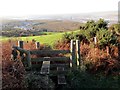
Bryngaer Penygaer Hillfort
Sticil ar fryngaer Penygaer uchlaw pentre Penclawdd. Yn y pellter gellir gweld aber Llwchwr ac anheddiad o'r enw Crofty.
A stile at Penygaer hillfort (trans. top of the fort) above the village of Penclawdd (trans. top of the rampart / dyke). In the distance one can see the Llwchwr estuary and the settlement known as Crofty (trans. croft's house).
Image: © Alan Richards
Taken: 8 Dec 2014
0.13 miles
2
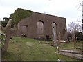
Ruined Chapel
A ruined chapel on the hill above Crofty
Image: © Hywel Williams
Taken: 17 Feb 2007
0.23 miles