IMAGES TAKEN NEAR TO
Cefn Stylle Road/Llwyn Mawr Lane, Cefn Stylle Road, SWANSEA, SA4 3QS
Introduction
This page details the photographs taken nearby to Cefn Stylle Road/Llwyn Mawr Lane, Cefn Stylle Road, SA4 3QS by members of the Geograph project.
The Geograph project started in 2005 with the aim of publishing, organising and preserving representative images for every square kilometre of Great Britain, Ireland and the Isle of Man.

There are currently over 7.5m images from over14,400 individuals and you can help contribute to the project by visiting https://www.geograph.org.uk
Image Map
Images are licensed for reuse under creativecommons.org/licenses/by-sa/2.0
Notes
- Clicking on the map will re-center to the selected point.
- The higher the marker number, the further away the image location is from the centre of the postcode.
Image Listing (8 Images Found)
Images are licensed for reuse under creativecommons.org/licenses/by-sa/2.0
Image
Details
Distance
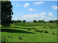
1
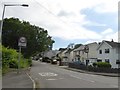
Cefnstyle Road, Gowerton
Residential housing along the west side, farmland on the opposite side
Image: © David Smith
Taken: 2 Jun 2018
0.09 miles
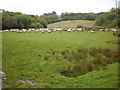
5
Rush pasture near Gowerton
Looking north west towards Loughor estuary. The Penclawdd branch line once passed across the foreground of the picture, running parallel to the road from Gowerton to Penclawdd.
Image: © Simon Mortimer
Taken: 9 Aug 2012
0.18 miles
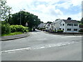
6
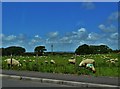
Grazing Sheep Near Gowerton
Grazing on fields on the road to Rhossili
Image: © Deborah Tilley
Taken: 6 Jun 2015
0.19 miles
7
Allt-wen Wood
Path crossing a small stream; path is now part of the Wales Coast Path.
Image: © Bart Horeman
Taken: 14 May 2012
0.23 miles
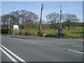
8
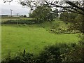
Grassland and hedges
View across grassland towards Cefn Stylle Farm.
Image: © Alan Hughes
Taken: 26 Jun 2019
0.24 miles