IMAGES TAKEN NEAR TO
Church Lane, SWANSEA, SA4 3JH
Introduction
This page details the photographs taken nearby to Church Lane, SA4 3JH by members of the Geograph project.
The Geograph project started in 2005 with the aim of publishing, organising and preserving representative images for every square kilometre of Great Britain, Ireland and the Isle of Man.

There are currently over 7.5m images from over14,400 individuals and you can help contribute to the project by visiting https://www.geograph.org.uk
Image Map (Loading...)


Getting Data...Please wait
Leaflet Map data © OpenStreetMap
Images are licensed for reuse under creativecommons.org/licenses/by-sa/2.0
Notes
- Clicking on the map will re-center to the selected point.
- The higher the marker number, the further away the image location is from the centre of the postcode.
Image Listing (17 Images Found)
Images are licensed for reuse under creativecommons.org/licenses/by-sa/2.0
Image
Details
Distance
1
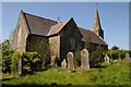
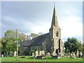
Church at Pen-Clawdd
Dedicated to St Gwynour
Image: © Philip Halling
Taken: 17 May 2014
0.09 miles
2
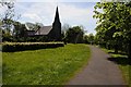
Path leading to St Gwynour?s Church
Church of St Gwynour, Penclawdd.
The Church of Llanernewydd, Penclawdd is dedicated to St. Gwynour, after a Breton Saint, Saint Eneour whose feast day is the 10th November.
Image: © Alan Hughes
Taken: 12 Dec 2018
0.09 miles
3
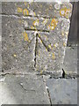
Ordnance Survey Cut Mark
This OS cut mark can be found on the NW face of St Gwynour's Church. It marks a point 75.533m above mean sea level.
Image: © Adrian Dust
Taken: 4 Jun 2015
0.09 miles
4
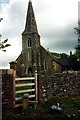
Pen-Clawdd church
St Gwynour's church, Pen-Clawdd silhouetted in the morning sun.
Image: © Philip Halling
Taken: 17 May 2014
0.09 miles
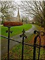
5
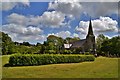
Grongaer Church Near Penclawdd
Originally the chapel of ease to Llanrhidian St Illtud in the parish, which was quite large at about 7 miles long
Image: © Deborah Tilley
Taken: 6 Jun 2015
0.09 miles
6
Church of St Gwynour, Penclawdd
High up on the hill above Penclawdd on the coast, this church is at the end of a couple of small back streets.
Image: © Nigel Davies
Taken: 10 Oct 2006
0.10 miles
7
Sticil Llanyrnewydd Stile
Sticil yn rhoi mynediad i Eglwys Llanyrnewydd. Ei henw gwreiddiol oedd Llanenewyr ac roedd yn gapel anwes i Lanrhidian.
A stile giving access to Llanyrnewydd Church. Originally known as Llanenewyr (trans. St Enewyr's Church) it was formerly a chapel of ease belonging to Llanrhidian.
Image: © Alan Richards
Taken: 2 Jun 1996
0.11 miles
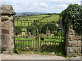
8
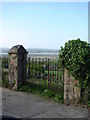
Gates at Pen-clawdd cemetery
Wonderful view for your final resting place!
Image: © Ian Paterson
Taken: 27 Apr 2011
0.12 miles
9

Llwybr Caban Isaac Path
Llwybr cyhoeddus yn myndd i gyfeiriad Heol yr Eglwys. Yn y pellter gellir gweld Eglwys Llanyrnewydd.
A public footpath heading in the direction of Church Road. Llanyrnewydd Church can be seen in the distance.
Image: © Alan Richards
Taken: 26 Jan 2015
0.12 miles