IMAGES TAKEN NEAR TO
Blue Anchor, Penclawdd, SWANSEA, SA4 3HY
Introduction
This page details the photographs taken nearby to SA4 3HY by members of the Geograph project.
The Geograph project started in 2005 with the aim of publishing, organising and preserving representative images for every square kilometre of Great Britain, Ireland and the Isle of Man.

There are currently over 7.5m images from over14,400 individuals and you can help contribute to the project by visiting https://www.geograph.org.uk
Image Map
Images are licensed for reuse under creativecommons.org/licenses/by-sa/2.0
Notes
- Clicking on the map will re-center to the selected point.
- The higher the marker number, the further away the image location is from the centre of the postcode.
Image Listing (7 Images Found)
Images are licensed for reuse under creativecommons.org/licenses/by-sa/2.0
Image
Details
Distance
1
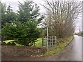
Footpath at Penyrheol
This footpath heads northwards from the road between Penclawdd and Three Crosses.
Image: © Alan Hughes
Taken: 12 Dec 2018
0.03 miles
2
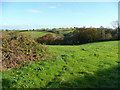
View north-east from Wernbwll
Pasture land on the north Gower ridge.
Image: © Jonathan Billinger
Taken: 12 Nov 2008
0.15 miles
3
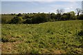
Site of Wernbwll Colliery
Site of Wernbwll Colliery where is November 1929 a mine explosion killed seven men. The colliery closed in 1937.
Image: © Philip Halling
Taken: 17 May 2014
0.16 miles
4
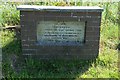
Mine memorial, Wernbwll Colliery
Memorial to the men who lost their lives in the Wernbwll Colliery explosion in 1929.
Image: © Philip Halling
Taken: 17 May 2014
0.17 miles
5

Colliery Memorial
The memorial refers to an explosion at Wernbwll in 1929, see http://www.welshcoalmines.co.uk/GlamWest/Wernbwll.htm
Image: © Jonathan Billinger
Taken: 12 Nov 2008
0.17 miles
6

Road at Wernbwll
An ex-mining community south-east of Pen-clawdd.
Image: © Jonathan Billinger
Taken: 12 Nov 2008
0.18 miles
7

Houses On The Roadside At Wernbwll
On the country road downhill into Penclawdd
Image: © Deborah Tilley
Taken: 6 Jun 2015
0.19 miles