IMAGES TAKEN NEAR TO
Cippyn, CARDIGAN, SA43 3LU
Introduction
This page details the photographs taken nearby to SA43 3LU by members of the Geograph project.
The Geograph project started in 2005 with the aim of publishing, organising and preserving representative images for every square kilometre of Great Britain, Ireland and the Isle of Man.

There are currently over 7.5m images from over14,400 individuals and you can help contribute to the project by visiting https://www.geograph.org.uk
Image Map (Loading...)


Getting Data...Please wait
Leaflet Map data © OpenStreetMap
Images are licensed for reuse under creativecommons.org/licenses/by-sa/2.0
Notes
- Clicking on the map will re-center to the selected point.
- The higher the marker number, the further away the image location is from the centre of the postcode.
Image Listing (17 Images Found)
Images are licensed for reuse under creativecommons.org/licenses/by-sa/2.0
Image
Details
Distance
1

Gerizim chapel gates
Seen across the parking area is a ruin, almost invisible under ivy and other vegetation. Old maps mark this as a smithy.
Image: © Natasha Ceridwen de Chroustchoff
Taken: 18 Jul 2008
0.16 miles
2
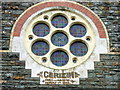
Capel Cerizim/Gerizim
There is some inconsistency over whether this chapel is named Cerizim or Gerizim. However it was built in 1848 and rebuilt in 1882. This unusually colourful window is described in Pevsner as a 'simplified Romanesque colander window of seven holes'.
Image: © Natasha Ceridwen de Chroustchoff
Taken: 18 Jul 2008
0.16 miles
3
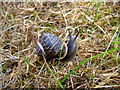
Snail (Helix aspersa) at Gerizim
Damp weather enabled snails to remain active in the grassy area surrounding Gerizim chapel but there was no graveyard.
Image: © Natasha Ceridwen de Chroustchoff
Taken: 18 Jul 2008
0.16 miles
4
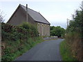
Chapel at Cippyn
The roadside chapel of Cerizim (or Gerizim) as seen when approaching from the west. Built in 1848, it replaced an earlier chapel (Soar) a short way further along at the bridge.
Image: © Natasha Ceridwen de Chroustchoff
Taken: 18 Jul 2008
0.17 miles
5

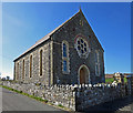
Capel Gerizim at Cippyn
Baptist chapel on elevated spot on quiet lane between Moylegrove and St Dogmael's in North Pembrokeshire. Mount Gerezim, or Cerizim, in Samaria is mentioned in the Old Testament as the place where God was to pronounce blessing upon the Jewish people and it remains a sacred place for the Samaritan people. See http://en.wikipedia.org/wiki/Mount_Gerizim
Image: © Natasha Ceridwen de Chroustchoff
Taken: 18 Jul 2008
0.17 miles
6
Gerizim Baptist Chapel, Cippyn
Founded in 1848. Cippyn is one of the four "Quarters" of St Dogmaels parish, occupying the high, peninsular part. The origin of the name is obscure.
Image: © Dylan Moore
Taken: 23 Apr 2016
0.17 miles
7

Gerazim Baptist Chapel
The chapel was built in 1847-48.
Image: © Rude Health
Taken: 12 Sep 2015
0.17 miles
8
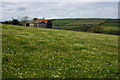
Spring flowers at Cippyn
Spring flowers in a field by Ffynnongog, Cippyn
Image: © Philip Halling
Taken: 7 May 2007
0.19 miles
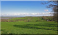
9
View from the chapel at Cippyn
Looking north towards Cippyn Fawr (left) and Delfryn (right) across the meltwater channel of Cwm yr Esgwyr.
Image: © Natasha Ceridwen de Chroustchoff
Taken: 18 Jul 2008
0.23 miles
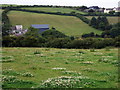
10
Field at Cippyn
Lush green pasture running down to the Teifi estuary.
Image: © Dylan Moore
Taken: 23 Apr 2016
0.24 miles