IMAGES TAKEN NEAR TO
St. Dogmaels, CARDIGAN, SA43 3HR
Introduction
This page details the photographs taken nearby to SA43 3HR by members of the Geograph project.
The Geograph project started in 2005 with the aim of publishing, organising and preserving representative images for every square kilometre of Great Britain, Ireland and the Isle of Man.

There are currently over 7.5m images from over14,400 individuals and you can help contribute to the project by visiting https://www.geograph.org.uk
Image Map (Loading...)


Getting Data...Please wait
Leaflet Map data © OpenStreetMap
Images are licensed for reuse under creativecommons.org/licenses/by-sa/2.0
Notes
- Clicking on the map will re-center to the selected point.
- The higher the marker number, the further away the image location is from the centre of the postcode.
Image Listing (156 Images Found)
Images are licensed for reuse under creativecommons.org/licenses/by-sa/2.0
Image
Details
Distance
1
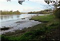
Teifi foreshore looking towards the Pinog
The Pinog was once the area where ships were built, berthed and maintained with local owners having individual moorings. It remains a designated village green where small craft are beached or tied up.
Image: © Natasha Ceridwen de Chroustchoff
Taken: 9 Nov 2022
0.03 miles
2
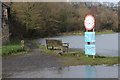
Wales Coast Path, St Dogmaels
By the Afon Teifi looking towards the sea at high water.
Image: © M J Roscoe
Taken: 23 Feb 2019
0.04 miles
3
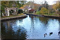
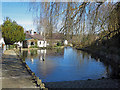
Mill pond, St Dogmaels
Part of the watermill can be seen to the left.
Image: © Trevor Harris
Taken: 28 Oct 2015
0.05 miles
4
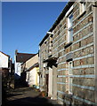
Vernacular building style, Llandudoch/St Dogmaels
A number of houses in the village display this local building feature of banding hard brown stone with layers of blueish-grey slatey marl. It makes a striking impression and the tradition seems to go back a long time since it also appears in the west wall of the abbey infirmary.
Image: © Natasha Ceridwen de Chroustchoff
Taken: 3 Feb 2007
0.05 miles
5
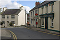
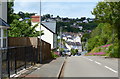
High Street, St Dogmaels
By a curious boundary quirk, St Dogmaels is in Pembrokeshire whereas the rest of the Teifi estuary is in Ceredigion.
Image: © Stephen McKay
Taken: 24 Mar 2008
0.05 miles
6
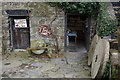
Y Felin (The Mill), St Dogmaels
This is one of the last working water mills in Wales. As the notice on the door indicates, wholemeal bread flour is available for purchase.
Image: © Stephen McKay
Taken: 24 Mar 2008
0.06 miles
7
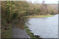
The Millpond, St Dogmaels
The mill (Y Felin) still operates. The pond is fed by Nant Degwell, which roars down the valley above the village even in dry weather. Like some other large Pembrokeshire parishes, St Dogmaels was divided into four "Quarters" or townships: Abbey, Cippyn, Pantygroes and Penybont. Although St Dogmaels is geographically in Pembrokeshire (the Teifi being the boundary), Abbey and Penybont Quarters were part of the ancient Borough of Cardigan, hence the complexity of the administrative boundaries. The boundary between Pantygroes and Penybont runs along Nant Degwell, so the right hand side of the view is in Penybont and the left hand side is in Pantygroes.
Image: © Dylan Moore
Taken: 14 Mar 2016
0.06 miles
8
Watery Wales Coast Path, St Dogmaels
Continuation downstream of path by Afon Teifi Image
Image: © M J Roscoe
Taken: 23 Feb 2019
0.06 miles
10
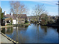
The Millpond, St Dogmaels
The mill (Y Felin) still operates. The pond is fed by Nant Degwell, which roars down the valley above the village even in dry weather. Like some other large Pembrokeshire parishes, St Dogmaels was divided into four "Quarters" or townships: Abbey, Cippyn, Pantygroes and Penybont. Although St Dogmaels is geographically in Pembrokeshire (the Teifi being the boundary), Abbey and Penybont Quarters were part of the ancient Borough of Cardigan, hence the complexity of the administrative boundaries. The boundary between Pantygroes and Penybont runs along Nant Degwell, so the right hand side of the view is in Penybont and the left hand side is in Pantygroes.
Image: © Dylan Moore
Taken: 14 Mar 2016
0.06 miles