IMAGES TAKEN NEAR TO
The Moorings, CARDIGAN, SA43 3GF
Introduction
This page details the photographs taken nearby to The Moorings, SA43 3GF by members of the Geograph project.
The Geograph project started in 2005 with the aim of publishing, organising and preserving representative images for every square kilometre of Great Britain, Ireland and the Isle of Man.

There are currently over 7.5m images from over14,400 individuals and you can help contribute to the project by visiting https://www.geograph.org.uk
Image Map
Images are licensed for reuse under creativecommons.org/licenses/by-sa/2.0
Notes
- Clicking on the map will re-center to the selected point.
- The higher the marker number, the further away the image location is from the centre of the postcode.
Image Listing (41 Images Found)
Images are licensed for reuse under creativecommons.org/licenses/by-sa/2.0
Image
Details
Distance
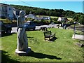
1
Mermaid Sculpture at the Moorings, St Dogmaels
There is a legend that a mermaid warned a local man, Pergrin, against danger and so saved his life from a fishing tragedy which cost 27 lives in 1789. The statue of the mermaid stands beside Glanteifion slipway.
Image: © Eirian Evans
Taken: 20 May 2015
0.01 miles
2
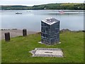
The end (or start) of the Pembrokeshire Coast Path
The marker for the path was unveiled in 2009.
Image: © Eirian Evans
Taken: 20 May 2015
0.02 miles
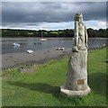
3
Peregrines Mermaid
Situated next to the Slipway and Jetty off the B4546 this carving was donated by Ian Gollop and John Clarke to celebrate the re unification of the village within Pembrokeshire April 2003.
Image: © Steve Houldsworth
Taken: 18 Jun 2017
0.02 miles
4
Statue beside the Teifi in St Dogmaels
Image: © Gareth James
Taken: 16 Aug 2015
0.02 miles
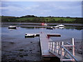
5
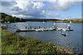
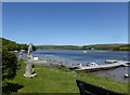
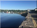
A quay in the Teifi estuary
It floats so that it can work with the tides.
Image: © Bill Boaden
Taken: 25 Aug 2011
0.02 miles
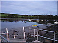
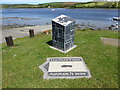
9
One end of the Pembrokeshire Coast Path National Trail, St Dogmaels
On the estuary of the River Teifi.
The ground sign shows that it is 186 miles to the other end of the path http://www.geograph.org.uk/photo/3988061 .
The River Teifi is the longest river which is wholly in Wales and flows 75 miles from its source in the Cambrian mountains to its estuary at Cardigan.
Image: © Robin Drayton
Taken: 5 Jul 2016
0.03 miles
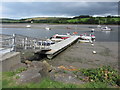
10
Landing stage
Landing jetty on the Teifi estuary.
Image: © Alan Hughes
Taken: 27 Jun 2018
0.03 miles