IMAGES TAKEN NEAR TO
Grove Terrace, CARDIGAN, SA43 3ER
Introduction
This page details the photographs taken nearby to Grove Terrace, SA43 3ER by members of the Geograph project.
The Geograph project started in 2005 with the aim of publishing, organising and preserving representative images for every square kilometre of Great Britain, Ireland and the Isle of Man.

There are currently over 7.5m images from over14,400 individuals and you can help contribute to the project by visiting https://www.geograph.org.uk
Image Map
Images are licensed for reuse under creativecommons.org/licenses/by-sa/2.0
Notes
- Clicking on the map will re-center to the selected point.
- The higher the marker number, the further away the image location is from the centre of the postcode.
Image Listing (149 Images Found)
Images are licensed for reuse under creativecommons.org/licenses/by-sa/2.0
Image
Details
Distance
1
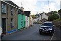
Feidr Fawr
Part of the main street through St Dogmaels.
Image: © Bill Boaden
Taken: 25 Aug 2011
0.01 miles
2

Phone booth: St Dogmaels
A good place for sunbathing.
Image: © Dylan Moore
Taken: 24 Mar 2019
0.02 miles
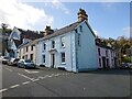
4
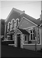
Bethsaida Baptist Chapel, Llandudoch/St Dogmaels
Originally dating from 1813 and rebuilt subsequently, this large chapel towards the top of the High Street has recently closed, I believe.
Image: © Natasha Ceridwen de Chroustchoff
Taken: 3 Feb 2007
0.03 miles
5
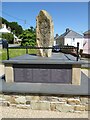
War memorial in St Dogmaels
This is a relatively new war memorial in St Dogmaels, it was unveiled on 11 November 2014, just over 100 years from the outbreak of the First World War, or the 'Great War' as it was known at the time.
Image: © Philip Halling
Taken: 16 Jul 2021
0.03 miles
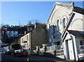
6
Bethsaida Chapel
Non-conformist Chapel in St Dogmaels, founded in 1926 - now a bed and breakfast.
Image: © Alan Hughes
Taken: 27 Jun 2018
0.04 miles
7
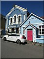
Bethsaida Baptist Chapel, St Dogmaels
Bethsaida Baptist Chapel was rebuilt in 1856, today it is no longer a chapel but offers bed and breakfast.
Image: © Philip Halling
Taken: 16 Jul 2021
0.04 miles
8
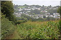
St Dogmaels
Part of the riverside village viewed across the Afon Teifi from the Wales Coast Path by a field of maize on an overcast day.
Image: © M J Roscoe
Taken: 17 Sep 2018
0.04 miles
9
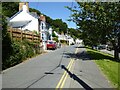
Pilot Street
Pilot Street in St Dogmaels.
Image: © Philip Halling
Taken: 16 Jul 2021
0.04 miles
10
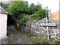
Llwybr Llygoden/Mouse Path, Llandudoch/St Dogmael's
One of the many ancient 'rat run' routes that twist and wind between houses and gardens up, down and across the village's steep hillside dwellings. This is the Feidr Fawr end.
Image: © Natasha Ceridwen de Chroustchoff
Taken: 9 Nov 2022
0.05 miles