IMAGES TAKEN NEAR TO
Moylegrove, CARDIGAN, SA43 3BW
Introduction
This page details the photographs taken nearby to SA43 3BW by members of the Geograph project.
The Geograph project started in 2005 with the aim of publishing, organising and preserving representative images for every square kilometre of Great Britain, Ireland and the Isle of Man.

There are currently over 7.5m images from over14,400 individuals and you can help contribute to the project by visiting https://www.geograph.org.uk
Image Map
Images are licensed for reuse under creativecommons.org/licenses/by-sa/2.0
Notes
- Clicking on the map will re-center to the selected point.
- The higher the marker number, the further away the image location is from the centre of the postcode.
Image Listing (34 Images Found)
Images are licensed for reuse under creativecommons.org/licenses/by-sa/2.0
Image
Details
Distance
1
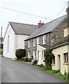
Village street, Moylgrove
Small village with the oldest part deep in a narrow valley a short way inland from the sea.
Image: © Gordon Hatton
Taken: 5 Apr 2019
0.00 miles
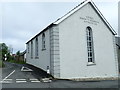
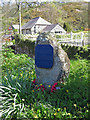
2
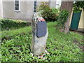
Moylegrove War Memorial
5 local men fell in the two World Wars and are commemorated here in the centre of Moyegrove.
Image: © Eirian Evans
Taken: 18 Jun 2019
0.01 miles
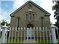
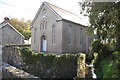
3
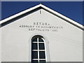
Bethel chapel, Trewyddel/Moylgrove
The inscription records that the original Independent chapel was founded here in 1691 although the present building dates from 1850. Interior "handsome" (Pevsner Architectural guide).
Image: © Natasha Ceridwen de Chroustchoff
Taken: 10 Feb 2007
0.01 miles
4
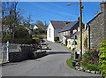
Moylgrove, Pembrokeshire
View with Bethel Independent Chapel at centre. Moylgrove means Matilda's Grove - possibly referring to the wife of Robert Fitzmartin, the first Norman invader of the area. The Welsh name of the parish is Trewyddel = "Irishman's farm" assuming that "gwyddel" here means Irishman, but "Placenames of Pembrokeshire" suggests it is a dialect word meaning "grove", which is more sensible.
Image: © Dylan Moore
Taken: 3 May 2016
0.01 miles
5
Capel Bethel, Trewyddel/Moylegrove
Bethel Independent Chapel was built in 1691, rebuilt/restored in 1837 and rebuilt/restored again in 1901.
Image: © Eirian Evans
Taken: 19 Jun 2019
0.01 miles
7
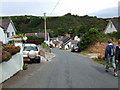
Entering Trewyddel/Moylgrove
The village lies in the deep Cwm Trewyddel valley a mile or so from the sea at Ceibwr Bay: the junction sign seen here indicates the direction.
The Welsh name Trewyddel means Irishman's place, suggestive of early visitations from the west, but the English name means Matilda's Grove and dates from Norman settlement. The village retains an English appearance although is linguistically Welsh notwithstanding a large proportion of holiday homes.
Image: © Natasha Ceridwen de Chroustchoff
Taken: 31 Aug 2007
0.02 miles
8
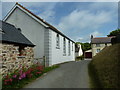
Ceibwr Bay to Moylgrove road entering Moylgrove
One of two chapels in the village is on the left.
Image: © Dave Spicer
Taken: 11 Jun 2012
0.02 miles
10
Chapel by the stream, Moylgrove
One of two chapels in the village, this is the Tabernacle Baptist Chapel (1894).
Image: © Trevor Harris
Taken: 28 Oct 2015
0.02 miles