IMAGES TAKEN NEAR TO
Llandygwydd, CARDIGAN, SA43 2QT
Introduction
This page details the photographs taken nearby to SA43 2QT by members of the Geograph project.
The Geograph project started in 2005 with the aim of publishing, organising and preserving representative images for every square kilometre of Great Britain, Ireland and the Isle of Man.

There are currently over 7.5m images from over14,400 individuals and you can help contribute to the project by visiting https://www.geograph.org.uk
Image Map
Images are licensed for reuse under creativecommons.org/licenses/by-sa/2.0
Notes
- Clicking on the map will re-center to the selected point.
- The higher the marker number, the further away the image location is from the centre of the postcode.
Image Listing (4 Images Found)
Images are licensed for reuse under creativecommons.org/licenses/by-sa/2.0
Image
Details
Distance
1
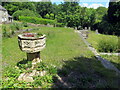
Safle Eglwys Llandygwydd / St Tygwydd's Church site
Dim ond y bedyddfaen a walydd isel yn unig sy'n goroesi o Eglwys Llandygwydd. Adeiladwyd yr addoldy hwn yn 1856-9. Fe'i dymchwelwyd yn 2000. Mae addolwyr yn cwrdd bellach yn hen ysgoldy'r babanod gerllaw.
Only the font and low walls are all that remain of St Tygwydd's church. Built in 1856-9 the church was demolished in 2000. Worshippers now meet in the adjacent former infant schoolroom.
Image: © Alan Richards
Taken: 1 Jun 2022
0.10 miles
2
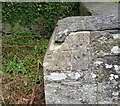
Ordnance Survey Cut Mark
This OS cut mark can be found on the remains of the porch of the ruin of St Tygwydd's Church. It marks a point 44.720m above mean sea level.
Image: © Adrian Dust
Taken: 7 Jun 2021
0.11 miles
3
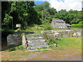
Safle Eglwys Llandygwydd / St Tygwydd Church site
Dim ond stepiau, y bedyddfaen a walydd isel yn unig sy'n goroesi o Eglwys Llandygwydd. Adeiladwyd yr addoldy hwn yn 1856-9. Fe'i dymchwelwyd yn 2000. Mae addolwyr yn cwrdd bellach yn hen ysgoldy'r babanod gerllaw.
Only steps, the font and low walls are all that remain of St Tygwydd's church. Built in 1856-9 the church was demolished in 2000. Worshippers now meet in the adjacent former infant schoolroom.
Image: © Alan Richards
Taken: 1 Jun 2022
0.11 miles
4
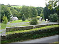
Foundations of the church of St. Tygwydd
Clearly the church built in 1857 stood here. The font is in the position marked on the ground plan http://www.churchplansonline.org/show_full_image.asp?resource_id=04734.tif . Indeed the boot scrapers are still in position by the steps up to the porch. But the church has completely disappeared. The only clue I have so far found is its mention in a list of listed buildings demolished in 1999 http://home.btconnect.com/ancientmonuments/LISTdem1999.doc .
A smaller building nearby is now used as the church http://www.dyfedfhs.org.uk/cgn/cgnlddd.htm
Image: © Roger W Haworth
Taken: 18 Sep 2007
0.12 miles