IMAGES TAKEN NEAR TO
CARDIGAN, SA43 2LA
Introduction
This page details the photographs taken nearby to SA43 2LA by members of the Geograph project.
The Geograph project started in 2005 with the aim of publishing, organising and preserving representative images for every square kilometre of Great Britain, Ireland and the Isle of Man.

There are currently over 7.5m images from over14,400 individuals and you can help contribute to the project by visiting https://www.geograph.org.uk
Image Map (Loading...)


Getting Data...Please wait
Leaflet Map data © OpenStreetMap
Images are licensed for reuse under creativecommons.org/licenses/by-sa/2.0
Notes
- Clicking on the map will re-center to the selected point.
- The higher the marker number, the further away the image location is from the centre of the postcode.
Image Listing (4 Images Found)
Images are licensed for reuse under creativecommons.org/licenses/by-sa/2.0
Image
Details
Distance
1
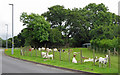
Goats opposite the Police Station, Cardigan
Image: © Dylan Moore
Taken: 16 Jul 2016
0.15 miles
2
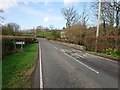
Pont Rhyd-y-fuwch, Llangoedmor
The North face of the North parapet used to bear an Ordnance Survey benchmark:
The mark was used on the Brecknock to Cardigan line of the First Primary Levelling of England & Wales in 1856. It was levelled with a height of 28.966' above OD (Liverpool). Description: 121. Mark on East pier of small bridge, over stream crossing road ; 5.19 ft. below top of parapet. Page 572 of the abstract: https://www.bench-marks.org.uk/abstract/ew1gl/1GLA_572.png
The mark was replaced by a BM on the South face at the West end of the parapet by 1904.
From the West: Image
Image: © N Scott
Taken: 22 Mar 2023
0.21 miles
3
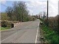
Pont Rhyd-y-fuwch, Llangoedmor
The North face of the North parapet used to bear an Ordnance Survey benchmark:
The mark was used on the Brecknock to Cardigan line of the First Primary Levelling of England & Wales in 1856. It was levelled with a height of 28.966' above OD (Liverpool). Description: 121. Mark on East pier of small bridge, over stream crossing road ; 5.19 ft. below top of parapet. Page 572 of the abstract: https://www.bench-marks.org.uk/abstract/ew1gl/1GLA_572.png
The mark was replaced by a BM on the South face at the West end of the parapet by 1904.
From the East: Image
Image: © N Scott
Taken: 22 Mar 2023
0.21 miles
4
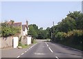
A484 passing the Equine Vets Clinic
Just prior to B4570 junction ahead
Image: © John Firth
Taken: 10 Jul 2013
0.23 miles