IMAGES TAKEN NEAR TO
Lon Yr Ysgol, CARDIGAN, SA43 2BB
Introduction
This page details the photographs taken nearby to Lon Yr Ysgol, SA43 2BB by members of the Geograph project.
The Geograph project started in 2005 with the aim of publishing, organising and preserving representative images for every square kilometre of Great Britain, Ireland and the Isle of Man.

There are currently over 7.5m images from over14,400 individuals and you can help contribute to the project by visiting https://www.geograph.org.uk
Image Map
Images are licensed for reuse under creativecommons.org/licenses/by-sa/2.0
Notes
- Clicking on the map will re-center to the selected point.
- The higher the marker number, the further away the image location is from the centre of the postcode.
Image Listing (3 Images Found)
Images are licensed for reuse under creativecommons.org/licenses/by-sa/2.0
Image
Details
Distance
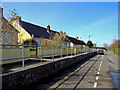
2
Small business units at Blaenporth
This site used to be the local infant school I think, but is now a little business park with a car sales lot, an electrical contractor, a Chiropractors and a tile shop by the looks of things.
Image: © Jeremy Bolwell
Taken: 3 Mar 2019
0.16 miles
3
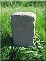
Old Milestone by the A487, Blaenporth, Aberporth parish
Cardigan low profile top by the A487, in parish of Aberporth (Ceredigion District), East of Blaenporth, on verge, South side of road.
Inscription reads:-
TO
CARDIGAN
6 MILES
Grade II listed by Cadw.
Reference Number: 16085 https://cadwpublic-api.azurewebsites.net/reports/listedbuilding/FullReport?lang=&id=16085
Surveyed
Milestone Society National ID: CRD_CAAY06
Image: © Milestone Society
Taken: Unknown
0.25 miles