IMAGES TAKEN NEAR TO
Brynhafod, CARDIGAN, SA43 1NS
Introduction
This page details the photographs taken nearby to Brynhafod, SA43 1NS by members of the Geograph project.
The Geograph project started in 2005 with the aim of publishing, organising and preserving representative images for every square kilometre of Great Britain, Ireland and the Isle of Man.

There are currently over 7.5m images from over14,400 individuals and you can help contribute to the project by visiting https://www.geograph.org.uk
Image Map
Images are licensed for reuse under creativecommons.org/licenses/by-sa/2.0
Notes
- Clicking on the map will re-center to the selected point.
- The higher the marker number, the further away the image location is from the centre of the postcode.
Image Listing (43 Images Found)
Images are licensed for reuse under creativecommons.org/licenses/by-sa/2.0
Image
Details
Distance
1
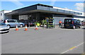
Cardigan Aldi
Aldi supermarket on the south side of the B4548 Aberystwyth Road.
Image: © Jaggery
Taken: 26 Jun 2015
0.10 miles
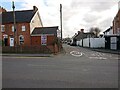
2
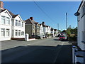
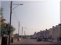
Feidr Henffordd
Houses on a quiet residential street just off the old main road out of Cardigan.
Image: © Richard Law
Taken: 18 Sep 2019
0.10 miles
3
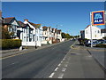
Up Aberystwyth Road
Looking out of Cardigan up what would have been the old main road north, prior to the construction of the present bypass.
Image: © Richard Law
Taken: 18 Sep 2019
0.10 miles
4
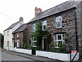
Old house in Feidrhenffordd
This house displays the banded-stone building technique that was used in this region for centuries. It is an attractive old place that could once have been a farm. The town expanded in this direction, northwards from its original nucleus around the bridge and the castle, during the last 3 decades of the C19 and became New Town.
A glance at the map explains the name of the street, which means old-road-lane: before the by-pass it was the route that connected Cardigan and Llangoedmor to the southeast. It is now a cul-se-sac with the new road cutting across the end.
Image: © Natasha Ceridwen de Chroustchoff
Taken: 24 Aug 2007
0.11 miles
5
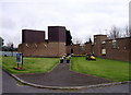
Catholic church and shrine, Aberteifi/Cardigan
Built 1970: unusual to see a modern church in this area.
From Wikipedia:
According to the legend, a statue of Our Lady and Child was found beside the River Teifi with a burning taper in her hand. The statue was taken to the local parish church, although it was moved several times before a church was specially built to house the shrine. The present St Mary's church dates back to around 1158, making the shrine more than 800 years old.
The original statue is believed to have been taken to London and destroyed in 1538 along with other Marian artefacts on the orders of Thomas Cromwell, 1st Earl of Essex, chief minister of King Henry VIII.
In 1952, the local bishop was informed that Cardigan had once possessed a famous shrine and pilgrimage site, and a new statue was carved based on the description of the original. The new statue was blessed at Westminster Cathedral in London and taken to every parish in the Diocese of Menevia before arriving in Cardigan where it was placed in Our Lady of Sorrows church. Four years later, a new church, Our Lady of the Taper, was consecrated, and the statue was placed in its current home.
See http://www.cardigantaper.org/shrine/story.htm for a fuller account.
Image: © Natasha Ceridwen de Chroustchoff
Taken: 24 Aug 2007
0.11 miles
6
Aberystwyth Road Cardigan
Heading towards Tesco
Image: © John Firth
Taken: 10 Jul 2013
0.11 miles
7
Catholic Church in Cardigan
Part of the Roman Catholic Diocese of Menevia, Our Lady of the Taper Catholic Church is set back
from the south side of Aberystwyth Road. See http://www.geograph.org.uk/photo/534795 for an earlier view and some details.
Image: © Jaggery
Taken: 26 Jun 2015
0.12 miles
8
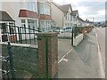
Wall, Delfan, Aberystwyth Road, Cardigan
The wall behind this gate-pier used to bear an Ordnance Survey rivet benchmark.
Height: 32.5222m OD (Newlyn). Mark verified by the Ordnance Survey in 1975. Description: NBM RIVET WALL DELFAN. 0.6m above ground. 3rd Order BM.
Image: © N Scott
Taken: 6 Mar 2022
0.12 miles
9
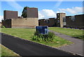
Junction of Feidr Henffordd, New Town, Cardigan
Henffordd Road became a dead-end road when it was bisected by the Cardigan bypass in 1980. There used to be a culvert at this junction, which bore an Ordnance Survey pivot benchmark:
The mark was used on the Warrington to Pembroke Docks line of the First Primary Levelling of England & Wales in 1851-1852. It was levelled with a height of 105.075' above OD (Liverpool). Description: 744. Mark on flag over gullet at junction of roads, East side of road ; 0.34 ft. below centre of road. Page 536 of the abstract: https://www.bench-marks.org.uk/abstract/ew1gl/1GLA_536.png
Image: © N Scott
Taken: 6 Mar 2022
0.14 miles
10
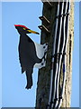
Woodpecker decoy in Aberystwyth Road, detail
A closer view of the woodpecker decoy on a telegraph, described here Image Note that it appears to represent a European black woodpecker and not an indigenous species.
Image: © Natasha Ceridwen de Chroustchoff
Taken: 18 Mar 2016
0.14 miles