IMAGES TAKEN NEAR TO
Rock Terrace, Quay Street, CARDIGAN, SA43 1HS
Introduction
This page details the photographs taken nearby to Rock Terrace, Quay Street, SA43 1HS by members of the Geograph project.
The Geograph project started in 2005 with the aim of publishing, organising and preserving representative images for every square kilometre of Great Britain, Ireland and the Isle of Man.

There are currently over 7.5m images from over14,400 individuals and you can help contribute to the project by visiting https://www.geograph.org.uk
Image Map
Images are licensed for reuse under creativecommons.org/licenses/by-sa/2.0
Notes
- Clicking on the map will re-center to the selected point.
- The higher the marker number, the further away the image location is from the centre of the postcode.
Image Listing (794 Images Found)
Images are licensed for reuse under creativecommons.org/licenses/by-sa/2.0
Image
Details
Distance
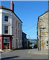
1
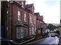
Houses on Quay street
These houses are "up market" compared to the little cottages on the other side of the street, could these properties be originally built for sea faring men.
Image: © chris whitehouse
Taken: 4 Aug 2012
0.00 miles
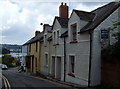
4
Quay Street, Cardigan
Terraced houses with a welcome hint of spring in the front gardens.
Image: © Stephen McKay
Taken: 24 Mar 2008
0.01 miles
5
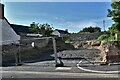
Cardigan: Building plot in a prime position
Image: © Michael Garlick
Taken: 11 Jun 2021
0.01 miles
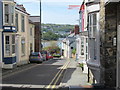
6
Stryd y Cei/Quay Street
Terraced cottages on the hill above Cardigan quay: once a centre for ships and sea-going commerce, now location of a supermarket and carpark.
Image: © Natasha Ceridwen de Chroustchoff
Taken: 25 Jul 2008
0.01 miles
7
New Life Christian Centre in Cardigan
Viewed across Quay Street.
Image: © Jaggery
Taken: 26 Jun 2015
0.02 miles
8
Quay Street, Cardigan
The River Teifi is in the distance.
Image: © Dylan Moore
Taken: 12 Oct 2010
0.02 miles
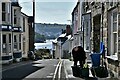
9
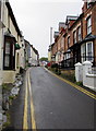
Quay Street, Cardigan
Quay Street climbs away from the north bank of the Afon Teifi, towards High Street and Green Street.
Double yellow lines on both sides of the road mean no parking at any time.
Image: © Jaggery
Taken: 26 Jun 2015
0.02 miles
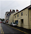
10
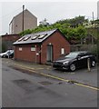
Lower Mwldan public toilets in Cardigan
Free facilities near the corner of Quay Street.
Image: © Jaggery
Taken: 26 Jun 2015
0.03 miles