IMAGES TAKEN NEAR TO
St. Mary Street, CARDIGAN, SA43 1HB
Introduction
This page details the photographs taken nearby to St. Mary Street, SA43 1HB by members of the Geograph project.
The Geograph project started in 2005 with the aim of publishing, organising and preserving representative images for every square kilometre of Great Britain, Ireland and the Isle of Man.

There are currently over 7.5m images from over14,400 individuals and you can help contribute to the project by visiting https://www.geograph.org.uk
Image Map (915 Images)


Leaflet Map data © OpenStreetMap
Images are licensed for reuse under creativecommons.org/licenses/by-sa/2.0
Notes
- Clicking on the map will re-center to the selected point.
- The higher the marker number, the further away the image location is from the centre of the postcode.
Image Listing (915 Images Found)
Images are licensed for reuse under creativecommons.org/licenses/by-sa/2.0
Image
Details
Distance
1
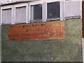
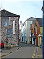
Sign for CADAMM
This building used to be part of the Farmers Feed Co-op, they moved to larger premises on Parc Teifi off the A484. Now the letters stand for Cardigan and District Agricultural and Maritime Museum; the Welsh version is AAMAC Amgueddfa Amaeth a Môr Aberteifi a'r Cylch.
Image: © chris whitehouse
Taken: 12 Dec 2012
0.01 miles
2
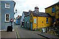
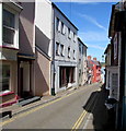
St Mary Street, Cardigan
Looking east along St Mary Street in Cardigan.
Image: © Jeff Buck
Taken: 27 Jun 2024
0.01 miles
3
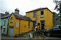
Three Little Pigs in Cardigan
Three Little Pigs Furniture and Home Ltd are based in the Old Stables in St Mary Road.
Image: © Jeff Buck
Taken: 27 Jun 2024
0.01 miles
4
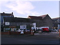
Eco Shop, Market and Museum
Site of the old Farmers Feed Co-operative, some of the buildings have been removed or demolished, seems to be a customer car park area also. Morgan Street.
Image: © chris whitehouse
Taken: 12 Dec 2012
0.02 miles
5
Black Lion Mews, Aberteifi/Cardigan
This old mews, originally belonging to the Black Lion Hotel, leads from High Street to Chancery Lane and houses some interesting shops. Note the attractive windows, paintwork and other architectural details that have been shown to their full advantage by virtue of the town's regeneration scheme.
Image: © Natasha Ceridwen de Chroustchoff
Taken: 7 Jun 2006
0.02 miles
6
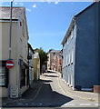
St Mary Street towards Cardigan town centre
Looking west along St Mary Street across Carrier's Lane near Morgan Street.
Double yellow lines on both sides of the street - no parking at any time.
Image: © Jaggery
Taken: 26 Jun 2015
0.02 miles
7
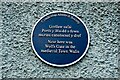
Wolfs Gate Blue Plaque in Cardigan
Plaque on a wall at the junction of Morgan Street and St Mary Street.
Image: © Jeff Buck
Taken: 27 Jun 2024
0.02 miles
8
East along St Mary Street, Cardigan
From the corner of High Street. Double yellow lines on both sides of the road - no parking at any time.
Image: © Jaggery
Taken: 26 Jun 2015
0.02 miles
10
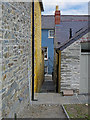
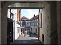
Alley: Cardigan Castle
This connects the Castle Green with St Marys Street.
Image: © Dylan Moore
Taken: 30 Jul 2015
0.02 miles