IMAGES TAKEN NEAR TO
Park Place, CARDIGAN, SA43 1AN
Introduction
This page details the photographs taken nearby to Park Place, SA43 1AN by members of the Geograph project.
The Geograph project started in 2005 with the aim of publishing, organising and preserving representative images for every square kilometre of Great Britain, Ireland and the Isle of Man.

There are currently over 7.5m images from over14,400 individuals and you can help contribute to the project by visiting https://www.geograph.org.uk
Image Map (Loading...)


Getting Data...Please wait
Leaflet Map data © OpenStreetMap
Images are licensed for reuse under creativecommons.org/licenses/by-sa/2.0
Notes
- Clicking on the map will re-center to the selected point.
- The higher the marker number, the further away the image location is from the centre of the postcode.
Image Listing (68 Images Found)
Images are licensed for reuse under creativecommons.org/licenses/by-sa/2.0
Image
Details
Distance
3
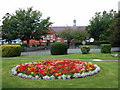
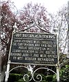
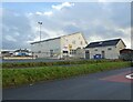
Ysgol Uwchradd Aberteifi/Cardigan Secondary School
Viewed from Victoria Gardens. Attractive late Victorian brick-built Intermediate School (originally) later expanded as a comprehensive school.
Image: © Natasha Ceridwen de Chroustchoff
Taken: 24 Aug 2007
0.08 miles
4
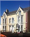
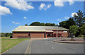
Brynhyfred Guest House
Brynhyfred Guest House on Gwbert Road, Cardigan.
Image: © Alan Hughes
Taken: 28 Jun 2018
0.08 miles
6
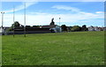
King George V Playing Fields, Cardigan
Rectangular area bounded by Park Avenue on the north side, Greenland Meadows
on the east, Aberystwyth Road on the south and Gwbert Road on the west.
Image: © Jaggery
Taken: 26 Jun 2015
0.10 miles
7
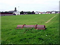
Greenland Meadows sportsground
This rectangular open space borders on North Street and Gwbert Road to the east and south; the northern and western perimeters are lined with houses.
Image: © Natasha Ceridwen de Chroustchoff
Taken: 24 Aug 2007
0.11 miles
8
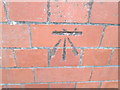
Ordnance Survey Cut Mark
This OS cut mark can be found on the Secondary School. It marks a point 23.515m above mean sea level.
Image: © Adrian Dust
Taken: 5 Apr 2015
0.11 miles
9
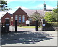
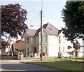
Ysgol Uwchradd Aberteifi (Cardigan Secondary School)
School entrance viewed from Victoria Gardens. http://www.geograph.org.uk/photo/4541759
Image: © Jaggery
Taken: 26 Jun 2015
0.12 miles