IMAGES TAKEN NEAR TO
Nevern, NEWPORT, SA42 0PB
Introduction
This page details the photographs taken nearby to SA42 0PB by members of the Geograph project.
The Geograph project started in 2005 with the aim of publishing, organising and preserving representative images for every square kilometre of Great Britain, Ireland and the Isle of Man.

There are currently over 7.5m images from over14,400 individuals and you can help contribute to the project by visiting https://www.geograph.org.uk
Image Map
Images are licensed for reuse under creativecommons.org/licenses/by-sa/2.0
Notes
- Clicking on the map will re-center to the selected point.
- The higher the marker number, the further away the image location is from the centre of the postcode.
Image Listing (5 Images Found)
Images are licensed for reuse under creativecommons.org/licenses/by-sa/2.0
Image
Details
Distance
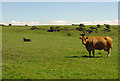
2
Tumulus, Bayvil
All that is visible is the rough tussock of grass in mid view.
Image: © Dylan Moore
Taken: 9 Aug 2012
0.15 miles
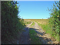
3
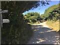
Country lane
Track at Pantygroes near Moylgrove.
Image: © Alan Hughes
Taken: 27 Jun 2018
0.21 miles