IMAGES TAKEN NEAR TO
CRYMYCH, SA41 3RT
Introduction
This page details the photographs taken nearby to SA41 3RT by members of the Geograph project.
The Geograph project started in 2005 with the aim of publishing, organising and preserving representative images for every square kilometre of Great Britain, Ireland and the Isle of Man.

There are currently over 7.5m images from over14,400 individuals and you can help contribute to the project by visiting https://www.geograph.org.uk
Image Map
Images are licensed for reuse under creativecommons.org/licenses/by-sa/2.0
Notes
- Clicking on the map will re-center to the selected point.
- The higher the marker number, the further away the image location is from the centre of the postcode.
Image Listing (4 Images Found)
Images are licensed for reuse under creativecommons.org/licenses/by-sa/2.0
Image
Details
Distance
1
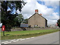
Anneddwen
The name of this roadside farm, between Eglwyswrw and Crymych, indicates it was once a 'white dwelling'.
Image: © Natasha Ceridwen de Chroustchoff
Taken: 28 Aug 2007
0.02 miles
2
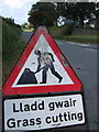
"Slaying the hay"
Welsh is an economical language: lladd means to slay or to kill as well as to cut/cut down; gwair serves for grass whether in its fresh or its dried form.
(As usual, the roadsign man seems to be wrestling with a giant umbrella!)
Image: © Natasha Ceridwen de Chroustchoff
Taken: 28 Aug 2007
0.02 miles
3
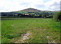
Field below Foel Drygarn
From the minor road junction at Anneddwen; Foel Drygarn (Three Cairn Hill) as usual draws the eye.
Image: © Natasha Ceridwen de Chroustchoff
Taken: 28 Aug 2007
0.18 miles
4
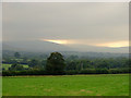
Field near Annedd-wen, Eglwys-wen
A brief shower passes over the Preseli ridge.
Image: © Dylan Moore
Taken: 27 Sep 2008
0.20 miles