IMAGES TAKEN NEAR TO
Carmarthen Road, SWANSEA, SA4 0TX
Introduction
This page details the photographs taken nearby to Carmarthen Road, SA4 0TX by members of the Geograph project.
The Geograph project started in 2005 with the aim of publishing, organising and preserving representative images for every square kilometre of Great Britain, Ireland and the Isle of Man.

There are currently over 7.5m images from over14,400 individuals and you can help contribute to the project by visiting https://www.geograph.org.uk
Image Map
Images are licensed for reuse under creativecommons.org/licenses/by-sa/2.0
Notes
- Clicking on the map will re-center to the selected point.
- The higher the marker number, the further away the image location is from the centre of the postcode.
Image Listing (12 Images Found)
Images are licensed for reuse under creativecommons.org/licenses/by-sa/2.0
Image
Details
Distance
1
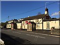
The Bird in the Hand
Pub on the A48 at Fforest, near Pontarddulais.
Image: © Alan Hughes
Taken: 5 Nov 2017
0.09 miles
3
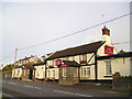
Heol y Plas
Housing in Heol y Plas, Fforest - above the A48.
Image: © Alan Hughes
Taken: 5 Nov 2017
0.14 miles
4
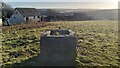
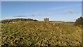
Derelict access hatch to Pontarddulais Royal Observer Corps bunker
The bunker's hatch structure is all that remains of this Royal Observer Corps bunker - and the bunker itself has been filled in relatively recently with stones and rubble to prevent access. The reason for this bunker's location is obvious, with its view over the Loughor estuary towards Swansea.
The reason for the infilling of the bunker way well be due to the proximity of the newly built housing nearby, seen in this image, though a number of nearby bunkers have also been blocked in a similar way by landowners in recent years.
Image: © Hywel Williams
Taken: 23 Jan 2021
0.15 miles
5
Remains of Pontarddualis Royal Observer Corps Post
This Royal Observer Corps nuclear bunker opened in 1962 and was closed in 1968. Little remains to be seen today apart from the small concrete hatch structure and the slightly raised ground at the top of the mound, under which the bunker was built. The air vents have long since gone and the bunker itself has now been filled in with stones and rubble to prevent access - the top of the ladder can still be seen inside the hatchway.
Image: © Hywel Williams
Taken: 26 Jan 2021
0.15 miles
6
Old Milestone by the A48, Fforest Road, Fforest
Carved stone post by A48, in the community of Llaneddi, Carmarthenshire; Fforest, East of junction with B4297 built into wall, North side of road. Probably C19th.
Inscription once read:-
(Swansea 10)
(Carmarthen 17)
Carved benchmark mid-left.
Milestone Society National ID: CAM_CMSW17.
Image: © Milestone Society
Taken: 13 Oct 2013
0.17 miles
7
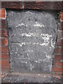
Mile Stone with Cut Mark
This Mile Stone can be found to the NE of Fforest Rd. It is 10 miles from Swansea. It carries an Ordnance Survey cut mark which marks a point 52.953m above mean sea level.
Image: © Adrian Dust
Taken: 13 Oct 2013
0.18 miles
8
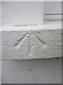
Ordnance Survey Pivot
This OS Pivot can be found on the window sill of No38 Llanedi Rd. It marks a point 69.586m above mean sea level.
Image: © Adrian Dust
Taken: 13 Oct 2013
0.19 miles
9
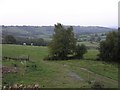
Loughor valley, north of Fforest
The Loughor river meanders down its valley shortly before becoming a tidal estuary.
Image: © Hywel Williams
Taken: 21 Sep 2006
0.21 miles
10
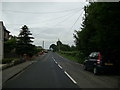
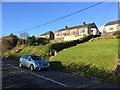
B4297 leaving Fforest
View of the B4297 heading for Llanedi from Fforest.
Image: © Martyn Harries
Taken: 27 Jul 2013
0.22 miles