IMAGES TAKEN NEAR TO
Carmarthen Road, SWANSEA, SA4 0TU
Introduction
This page details the photographs taken nearby to Carmarthen Road, SA4 0TU by members of the Geograph project.
The Geograph project started in 2005 with the aim of publishing, organising and preserving representative images for every square kilometre of Great Britain, Ireland and the Isle of Man.

There are currently over 7.5m images from over14,400 individuals and you can help contribute to the project by visiting https://www.geograph.org.uk
Image Map
Images are licensed for reuse under creativecommons.org/licenses/by-sa/2.0
Notes
- Clicking on the map will re-center to the selected point.
- The higher the marker number, the further away the image location is from the centre of the postcode.
Image Listing (9 Images Found)
Images are licensed for reuse under creativecommons.org/licenses/by-sa/2.0
Image
Details
Distance
1
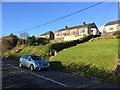
Heol y Plas
Housing in Heol y Plas, Fforest - above the A48.
Image: © Alan Hughes
Taken: 5 Nov 2017
0.03 miles
3
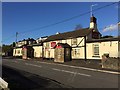
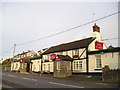
The Bird in the Hand
Pub on the A48 at Fforest, near Pontarddulais.
Image: © Alan Hughes
Taken: 5 Nov 2017
0.08 miles
4
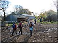
Plas y Fforest Farm
Cerddwyr yn mynd heibio i adeiladau amaethyddol Ffarm Plas y Fforest.
Walkers passing agricultural buildings at Plas y Fforest Farm.
Image: © Alan Richards
Taken: 21 Oct 2012
0.16 miles
5
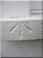
Ordnance Survey Pivot
This OS Pivot can be found on the window sill of No38 Llanedi Rd. It marks a point 69.586m above mean sea level.
Image: © Adrian Dust
Taken: 13 Oct 2013
0.17 miles
6
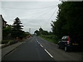
B4297 leaving Fforest
View of the B4297 heading for Llanedi from Fforest.
Image: © Martyn Harries
Taken: 27 Jul 2013
0.19 miles
7
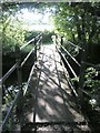
Footbridge over the Gwili
This bridge allows pedestrians to cross the Gwili avoiding the nearby ford (which is almost impossible for vehicles to use too!)
Image: © Hywel Williams
Taken: 6 Aug 2007
0.23 miles
8
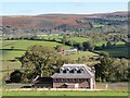
Fforest
Edrych i lawr at anhedd-dy newydd yn y Fforest o lwybr cyhoeddus. Y ffarm yng nghanol y llun yw Talfan Fawr a'r ucheldir yn y pellter yw Graig Fawr (Fe'i hadwaenir yn lleol hefyd yn 'Jericho').
Looking down on a new property in Fforest from a public footpath. The farm in the centre of the photo is Talfan Fawr (trans. [farm] at the end of the hill) and the bracken covered upland in the distance is known as Graig Fawr (trans. Big Hill) but also known locally as 'Jericho'.
Image: © Alan Richards
Taken: 21 Oct 2012
0.24 miles
9

Forgotten Road
One of a number of forgotten or abandoned roads in the area. Many have lost their statuses as roads due to the construction of the nearby M4 motorway. This one however probably became mostly disused as there are far better crossings of the Gwili railway nearby. Here, there is only a ford that is, by today only suitable for 4x4 vehicles.
Image: © Hywel Williams
Taken: 5 May 2019
0.25 miles