IMAGES TAKEN NEAR TO
Maescader, PENCADER, SA39 9HR
Introduction
This page details the photographs taken nearby to Maescader, SA39 9HR by members of the Geograph project.
The Geograph project started in 2005 with the aim of publishing, organising and preserving representative images for every square kilometre of Great Britain, Ireland and the Isle of Man.

There are currently over 7.5m images from over14,400 individuals and you can help contribute to the project by visiting https://www.geograph.org.uk
Image Map
Images are licensed for reuse under creativecommons.org/licenses/by-sa/2.0
Notes
- Clicking on the map will re-center to the selected point.
- The higher the marker number, the further away the image location is from the centre of the postcode.
Image Listing (46 Images Found)
Images are licensed for reuse under creativecommons.org/licenses/by-sa/2.0
Image
Details
Distance
1
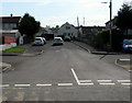
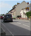
Maes Cader, Pencader
Maes Cader is an area of houses on the east side of the B4459, the main road through the village.
Image: © Jaggery
Taken: 1 Aug 2019
0.02 miles
2
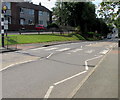
Zebra crossing in Pencader
Across the B4459, the main road through the village.
Image: © Jaggery
Taken: 1 Aug 2019
0.04 miles
3
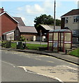
Bus stop and shelter alongside the B4459, Pencader
This is a stop on TrawsCymru bus route T1 to Carmarthen.
Image: © Jaggery
Taken: 1 Aug 2019
0.04 miles
4
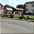
Dark green cabinets alongside the B4459 in Pencader
Two telecoms cabinets viewed in August 2019. No cabinets were here in a July 2011 Google Street View.
Image: © Jaggery
Taken: 1 Aug 2019
0.05 miles
5
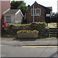
Queen Elizabeth II postbox alongside the B4459 in Pencader
Near a large flower tub on the east side of the main road through the village.
Image: © Jaggery
Taken: 1 Aug 2019
0.06 miles
6
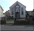
Former Moriah Chapel, Pencader
In August 2019 the former chapel is in secular use. The notice on the left shows
HOUSE CLEARANCES WANTED - WE BUY & SELL ANTIQUES & VINTAGE ITEMS.
The year 1897 is on the Moriah name tablet. https://www.geograph.org.uk/photo/6226424
Image: © Jaggery
Taken: 1 Aug 2019
0.06 miles
7
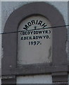
Moriah 1897, Pencader
On this https://www.geograph.org.uk/photo/6226421 former chapel.
Image: © Jaggery
Taken: 1 Aug 2019
0.06 miles
8
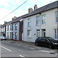
Pencader houses
On the east side of the B4459, the main road through Pencader.
Image: © Jaggery
Taken: 1 Aug 2019
0.09 miles
9
Zebra crossing warning sign, Pencader
The sign on the right is on the approach to this https://www.geograph.org.uk/photo/6225981 crossing on the B4459, the main road through Pencader.
Image: © Jaggery
Taken: 1 Aug 2019
0.10 miles
10
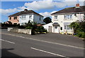
Pencader semis
Semi-detached houses on the west side of the B4459, the main road through Pencader.
Image: © Jaggery
Taken: 1 Aug 2019
0.11 miles