IMAGES TAKEN NEAR TO
PENCADER, SA39 9BU
Introduction
This page details the photographs taken nearby to SA39 9BU by members of the Geograph project.
The Geograph project started in 2005 with the aim of publishing, organising and preserving representative images for every square kilometre of Great Britain, Ireland and the Isle of Man.

There are currently over 7.5m images from over14,400 individuals and you can help contribute to the project by visiting https://www.geograph.org.uk
Image Map
Images are licensed for reuse under creativecommons.org/licenses/by-sa/2.0
Notes
- Clicking on the map will re-center to the selected point.
- The higher the marker number, the further away the image location is from the centre of the postcode.
Image Listing (34 Images Found)
Images are licensed for reuse under creativecommons.org/licenses/by-sa/2.0
Image
Details
Distance
1
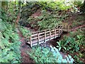
Pompren / Footbridge
Pompren yn rhychwantu nant sych ym Mhencader.
A footbridge spanning a dried up stream in Pencader.
Image: © Alan Richards
Taken: 10 Jul 2014
0.08 miles
2
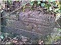
Ordnance Survey Cut Mark
This OS cut mark can be found on the brick drain NW side of the road. It marks a point 165.595m above mean sea level.
Image: © Adrian Dust
Taken: 8 Nov 2019
0.11 miles
3
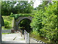
Bridge carrying dismantled railway over the Afon Talog, Pencader
Image: © John Lord
Taken: 10 Aug 2013
0.18 miles
4
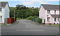
Bro'r Hen Wr, Pencader
On the west side of the B4459, Bro'r Hen Wr is a dead-end street with a Welsh-only name.
Image: © Jaggery
Taken: 1 Aug 2019
0.18 miles
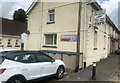
6
Branney's in Pencader
Branney's fish bar, café & takeaway is in Bridge House on
the west side of the B4459, the main road through Pencader.
Image: © Jaggery
Taken: 1 Aug 2019
0.19 miles
7
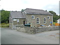
Yr Hen Capel, Pencader
Former chapel, now community centre.
Image: © John Lord
Taken: 10 Aug 2013
0.19 miles
8
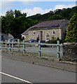
Yr Hen Gapel, Pencader
Welsh for The Old Chapel, Yr Hen Gapel is in secular use in 2019. The chapel was built in 1827 replacing an earlier building of 1780. It was superseded when nearby Capel Tabernacl (Tabernacle Chapel) https://www.geograph.org.uk/photo/6226487 opened in 1910.
Yr Hen Gapel was Grade II Listed in 1997.
Image: © Jaggery
Taken: 1 Aug 2019
0.19 miles
9
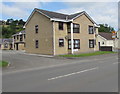
Bro Castell, Pencader
The name sign on the corner shows BRO CASTELL Rhif 1-10. Rhif is Welsh for number.
Image: © Jaggery
Taken: 1 Aug 2019
0.20 miles
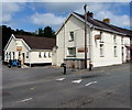
10
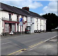
Derelict former shop in Pencader
A BT phonebox is at the edge of the former shop on
the west side of the B4459, the main road through Pencader.
On August 1st 2019, the unnamed former shop looks little
changed from its appearance in a June 2011 Google Street View.
Image: © Jaggery
Taken: 1 Aug 2019
0.20 miles