IMAGES TAKEN NEAR TO
Ardwyn Terrace, NEWCASTLE EMLYN, SA38 9EF
Introduction
This page details the photographs taken nearby to Ardwyn Terrace, SA38 9EF by members of the Geograph project.
The Geograph project started in 2005 with the aim of publishing, organising and preserving representative images for every square kilometre of Great Britain, Ireland and the Isle of Man.

There are currently over 7.5m images from over14,400 individuals and you can help contribute to the project by visiting https://www.geograph.org.uk
Image Map
Images are licensed for reuse under creativecommons.org/licenses/by-sa/2.0
Notes
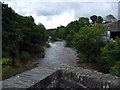
- Clicking on the map will re-center to the selected point.
- The higher the marker number, the further away the image location is from the centre of the postcode.
Image Listing (309 Images Found)
Images are licensed for reuse under creativecommons.org/licenses/by-sa/2.0
Image
Details
Distance
1
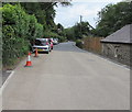
Riverbank part of the A475, Adpar, Ceredigion
This part of the A475 is on the north bank of the River Teifi.
Pointing ahead, a nearby brown sign https://www.geograph.org.uk/photo/6225281 shows Teifi Valley Railway.
Image: © Jaggery
Taken: 13 Jul 2019
0.00 miles
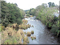
2
River Teifi between Adpar and Newcastle Emlyn
From Adpar Bridge - only the third crossing place above Cardigan. To the right is Ceredigion; to the left is Carmarthenshire.
Image: © Dylan Moore
Taken: 23 Oct 2013
0.02 miles
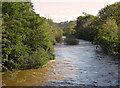
3
Upstream along the Teifi, Newcastle Emlyn
Viewed from this https://www.geograph.org.uk/photo/6225265 bridge. The river here marks the boundary between Ceredigion (left side) and Carmarthenshire.
Image: © Jaggery
Taken: 13 Jul 2019
0.02 miles
4
Converted mill: Adpar
This was originally the Ffrwd-wen woollen mill, powered by water from the mill dam 230 m to the west. The leet was culverted under the road just to the right of this view. In view of the fact that the mill is well above the dam, it must have been driven by a Pelton wheel below the road level. The river falls about 3 m between the dam and the bridge, and there were mills on both sides, relying on volume rather than fall for their power.
Image: © Dylan Moore
Taken: 27 Nov 2014
0.02 miles
5
Afon Teifi in Newcastle Emlyn
This view is looking upstream from the A475 road bridge.
Image: © Stuart Logan
Taken: 8 Oct 2011
0.03 miles
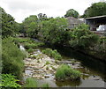
6
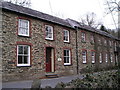
Cilgwyn Mill
Mill house to left and woollen mill to right.
Image: © Marion Phillips
Taken: 28 Feb 2008
0.03 miles
7
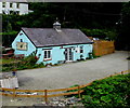
Riverside Coffee Shop & Cafe, Adpar, Ceredigion
Located on the north bank of the River Teifi near Newcastle Emlyn and Carmarthenshire.
Image: © Jaggery
Taken: 13 Jul 2019
0.03 miles
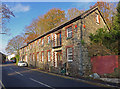
8
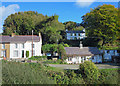
Houses near Adpar Bridge
In the clump of trees to the left is the motte of Adpar Castle.
Image: © Dylan Moore
Taken: 23 Oct 2013
0.04 miles
9
Afon Teifi from the bridge
Looking east, upstream, from one of the cutwaters of Newcastle Emlyn bridge, which dates from the C18. Heavy rainfall has swollen the river.
Image: © Natasha Ceridwen de Chroustchoff
Taken: 12 Aug 2008
0.04 miles
10
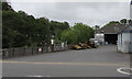
Yard on the south bank of the Teifi, Newcastle Emlyn
Set back from the east side of the A475 Bridge Street. The name on the building
in the background is Clynderwen & Cardiganshire Farmers Ltd and its Welsh equivalent.
Image: © Jaggery
Taken: 13 Jul 2019
0.04 miles