IMAGES TAKEN NEAR TO
Coedmore Terrace, NEWCASTLE EMLYN, SA38 9DS
Introduction
This page details the photographs taken nearby to Coedmore Terrace, SA38 9DS by members of the Geograph project.
The Geograph project started in 2005 with the aim of publishing, organising and preserving representative images for every square kilometre of Great Britain, Ireland and the Isle of Man.

There are currently over 7.5m images from over14,400 individuals and you can help contribute to the project by visiting https://www.geograph.org.uk
Image Map
Images are licensed for reuse under creativecommons.org/licenses/by-sa/2.0
Notes
- Clicking on the map will re-center to the selected point.
- The higher the marker number, the further away the image location is from the centre of the postcode.
Image Listing (283 Images Found)
Images are licensed for reuse under creativecommons.org/licenses/by-sa/2.0
Image
Details
Distance
1
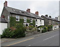
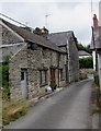
Stone houses alongside the B4571, Adpar, Ceredigion
The gap between houses is near the Coedmore Lane junction.
Image: © Jaggery
Taken: 13 Jul 2019
0.00 miles
2
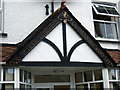
Ye Olde Drovers date sign
Site, it would seem, of a C16 inn, replaced by a shop 500 years later, and now housing a veterinary practice (which would have been useful to the old drovers transporting valuable beef and pork on the hoof!)
Image: © Natasha Ceridwen de Chroustchoff
Taken: 12 Aug 2008
0.01 miles
3
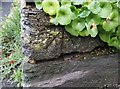
Ordnance Survey Cut Mark
This OS cut mark can be found on the wall NW side of the road. It marks a point 41.642m above mean sea level.
Image: © Adrian Dust
Taken: 29 Feb 2020
0.01 miles
4
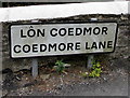
Coedmore Lane bilingual name sign, Adpar, Ceredigion
The sign on the left here https://www.geograph.org.uk/photo/6210442 shows that Coedmore Lane is Lôn Coedmor in Welsh.
Image: © Jaggery
Taken: 13 Jul 2019
0.01 miles
5
Stone houses, Coedmore Lane, Adpar, Ceredigion
On the approach to the B4571 junction.
Image: © Jaggery
Taken: 13 Jul 2019
0.01 miles
6
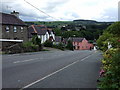
Down into Adpar
The road from the north dips down into the settlement of Adpar which is contiguous, via the bridge over the Teifi, with Newcastle Emlyn whose church tower can be seen in the distance here.
Adpar used to be a borough in its own right. It has been suggested that the name derives from At-pawr (At-Pori) - meaning a good 'second crop' for grazing in the rich Teifi valley pasture lands. When English settlers arrived in the area Atpawr became known as Atpar and over the years changed yet again to Adpar. The original Welsh name was Trehedyn (seed place?)
Image: © Natasha Ceridwen de Chroustchoff
Taken: 12 Aug 2008
0.02 miles
7
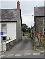
Coedmore Lane, Adpar, Ceredigion
Dead-end lane on the west side of the B4571.
Image: © Jaggery
Taken: 13 Jul 2019
0.02 miles
8
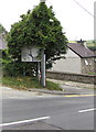
Directions sign alongside the B4571, Adpar, Ceredigion
On the descent to the valley of the Afon Teifi and Newcastle Emlyn in Carmarthenshire.
Partly hidden by leaves in July 2019, the sign shows the routes to Lampeter, Carmarthen, Aberporth.
Image: © Jaggery
Taken: 13 Jul 2019
0.02 miles
9
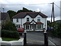
Ye Olde Drovers
This is now a veterinary surgery but according to the inscription over the porch was once "The Old Drovers" (presumably an inn) in 1526!
It was rebuilt as The Drovers Stores in 1926.
This would have been on the route for drovers herding hogs and cattle from mid and west Wales to market in Carmarthen and all points east, including London.
Image: © Natasha Ceridwen de Chroustchoff
Taken: 12 Aug 2008
0.02 miles
10
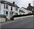
White houses alongside the B4571, Adpar, Ceredigion
On the ascent away from the Teifi valley and Newcastle Emlyn in Carmarthenshire.
Image: © Jaggery
Taken: 13 Jul 2019
0.02 miles