IMAGES TAKEN NEAR TO
Cwrt Dolwerdd, BONCATH, SA37 0JQ
Introduction
This page details the photographs taken nearby to Cwrt Dolwerdd, SA37 0JQ by members of the Geograph project.
The Geograph project started in 2005 with the aim of publishing, organising and preserving representative images for every square kilometre of Great Britain, Ireland and the Isle of Man.

There are currently over 7.5m images from over14,400 individuals and you can help contribute to the project by visiting https://www.geograph.org.uk
Image Map (Loading...)


Getting Data...Please wait
Leaflet Map data © OpenStreetMap
Images are licensed for reuse under creativecommons.org/licenses/by-sa/2.0
Notes
- Clicking on the map will re-center to the selected point.
- The higher the marker number, the further away the image location is from the centre of the postcode.
Image Listing (12 Images Found)
Images are licensed for reuse under creativecommons.org/licenses/by-sa/2.0
Image
Details
Distance
1
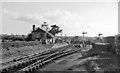
Boncath Station
View SW, towards Whitland; ex-GWR Whitland - Cardigan branch. Station and line closed to passengers 10/9/62, to goods 27/9/63.
Image: © Ben Brooksbank
Taken: 1 Jun 1962
0.13 miles
2
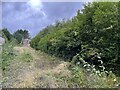
Boncath railway station (site), Pembrokeshire
Opened in 1886 by the Whitland and Taf Vale Railway, later part of the Great Western Railway, on the line from Whitland to Cardigan, this station closed to passengers in 1962 and completely in 1963.
View south west towards Crymmych Arms and Whitland from the platform. The station building was still extant when this image was taken, but the track-bed heavily overgrown.
For more information, see http://www.disused-stations.org.uk/b/boncath/index.shtml.
Image: © Nigel Thompson
Taken: 5 Sep 2022
0.14 miles
3
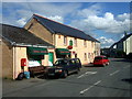
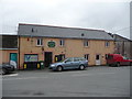
Central Boncath: shop and post office
C19 crossroads village in northeast Pembrokeshire that grew up around the arrival of the now-defunct railway. The name mean Buzzard, a bird which is frequent hereabouts.
Image: © Natasha Ceridwen de Chroustchoff
Taken: 29 Jun 2007
0.17 miles
4
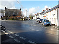
The centre of Boncath
With the Boncath Inn on the left of the road and the post office opposite. It was here I first came across signs of a rain shower having experienced dry conditions to the west.
Image: © John Baker
Taken: 24 Mar 2015
0.20 miles

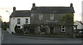
6

The Boncath Inn
Nice looking village public house.
Image: © Jeremy Bolwell
Taken: 4 May 2013
0.21 miles
7
Siop y Pentref / Boncath Mini-market and Post Office
An obvious hub of village life on the crossroads here. Ideal stop-off for passers-by, like me, to top up on life's little essentials, a chat or banter with the staff and locals and break up a long car journey.
Image: © Jeremy Bolwell
Taken: 4 May 2013
0.22 miles
8
Boncath Inn
This pub is the closest to the Eisteddfod and I expect the landlord was expecting a very busy time over the Eisteddfod period. There is Eisteddfod bunting (red green and white) draped about the pergola across the front.
Image: © chris whitehouse
Taken: 26 May 2013
0.22 miles
9
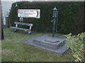
Village pump
Boncath water supply as it was years ago before mains water was piped in.
Image: © chris whitehouse
Taken: 26 May 2013
0.23 miles
10
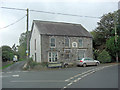
Dwelling beside the B4332
On the front of this stone house is the motif Lawell y Grub 1895.
Image: © Stuart Logan
Taken: 5 Oct 2011
0.23 miles