IMAGES TAKEN NEAR TO
Blaenffos, BONCATH, SA37 0HY
Introduction
This page details the photographs taken nearby to SA37 0HY by members of the Geograph project.
The Geograph project started in 2005 with the aim of publishing, organising and preserving representative images for every square kilometre of Great Britain, Ireland and the Isle of Man.

There are currently over 7.5m images from over14,400 individuals and you can help contribute to the project by visiting https://www.geograph.org.uk
Image Map
Images are licensed for reuse under creativecommons.org/licenses/by-sa/2.0
Notes
- Clicking on the map will re-center to the selected point.
- The higher the marker number, the further away the image location is from the centre of the postcode.
Image Listing (5 Images Found)
Images are licensed for reuse under creativecommons.org/licenses/by-sa/2.0
Image
Details
Distance
2
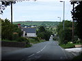
Entering Blaenffos from the south
The settlement straggles along the historically important Cardigan-Narberth road (now the A478) as it plunges down into a deep valley north of Crymych.
Image: © Natasha Ceridwen de Chroustchoff
Taken: 29 Jun 2007
0.07 miles
3
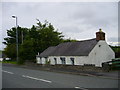
Cottage in Blaenffos
on the main street (A478). The trees on the left are in what was a cutting of the Whitland and Cardigan Branch of the GWR. The cottage is below road level and probably seemed even lower in the past because the road may have crossed the railway with a hump bridge at this point.
Image: © Roger W Haworth
Taken: 3 Jun 2007
0.07 miles
5
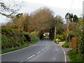
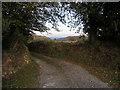
Through a sylvan arch
The A478 entering Blaenffos.
Image: © John H Darch
Taken: 23 Oct 2019
0.21 miles