IMAGES TAKEN NEAR TO
Hermon, GLOGUE, SA36 0DZ
Introduction
This page details the photographs taken nearby to SA36 0DZ by members of the Geograph project.
The Geograph project started in 2005 with the aim of publishing, organising and preserving representative images for every square kilometre of Great Britain, Ireland and the Isle of Man.

There are currently over 7.5m images from over14,400 individuals and you can help contribute to the project by visiting https://www.geograph.org.uk
Image Map
Images are licensed for reuse under creativecommons.org/licenses/by-sa/2.0
Notes
- Clicking on the map will re-center to the selected point.
- The higher the marker number, the further away the image location is from the centre of the postcode.
Image Listing (2 Images Found)
Images are licensed for reuse under creativecommons.org/licenses/by-sa/2.0
Image
Details
Distance
1
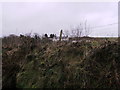
Lleban Hermon
Need steps to get better photo than this! One of the farms of the area with "Lleban" in the name.
Image: © chris whitehouse
Taken: 14 Feb 2012
0.17 miles
2
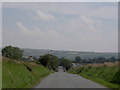
Hermon and Gwyl y Garreg Las
Looking into the village of Hermon along the straight road from Crymych. The tents of the Celtic Blue Rock festival (Gwyl y Garreg Las, Image) can be seen clearly on the skyline.
Image: © Patrick
Taken: 5 Aug 2007
0.24 miles