IMAGES TAKEN NEAR TO
Hebron, WHITLAND, SA34 0XU
Introduction
This page details the photographs taken nearby to SA34 0XU by members of the Geograph project.
The Geograph project started in 2005 with the aim of publishing, organising and preserving representative images for every square kilometre of Great Britain, Ireland and the Isle of Man.

There are currently over 7.5m images from over14,400 individuals and you can help contribute to the project by visiting https://www.geograph.org.uk
Image Map (Loading...)


Getting Data...Please wait
Leaflet Map data © OpenStreetMap
Images are licensed for reuse under creativecommons.org/licenses/by-sa/2.0
Notes
- Clicking on the map will re-center to the selected point.
- The higher the marker number, the further away the image location is from the centre of the postcode.
Image Listing (6 Images Found)
Images are licensed for reuse under creativecommons.org/licenses/by-sa/2.0
Image
Details
Distance
1
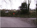
End of the metaled road
Council road stops here! Llwyn-mynydd to the right, Berllandawel and Brynawel to the left.
Image: © chris whitehouse
Taken: 27 Feb 2012
0.20 miles
2
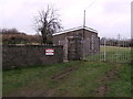
Ty Bach Capel
Entrance to graveyard. Vegetable garden behind wall on left.
Image: © chris whitehouse
Taken: 27 Feb 2012
0.21 miles
4
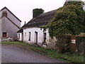
Y-Bwthyn
Rear of Chapel is this cottage, no longer inhabited, but it had two fireplaces! The building has had many uses over the decades.
Image: © chris whitehouse
Taken: 27 Feb 2012
0.23 miles
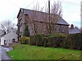
5
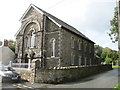
Hebron chapel
Now looking at its best again (see Image), but all the telephone wires are a bit distracting.
Image: © David Purchase
Taken: 26 Sep 2019
0.24 miles
6
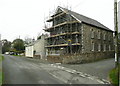
Hebron Chapel, Cilymaenllwyd
Not looking at its best, but I could not wait for the work to be finished!
Image: © Humphrey Bolton
Taken: 25 Oct 2016
0.24 miles