IMAGES TAKEN NEAR TO
Llanboidy, WHITLAND, SA34 0EU
Introduction
This page details the photographs taken nearby to SA34 0EU by members of the Geograph project.
The Geograph project started in 2005 with the aim of publishing, organising and preserving representative images for every square kilometre of Great Britain, Ireland and the Isle of Man.

There are currently over 7.5m images from over14,400 individuals and you can help contribute to the project by visiting https://www.geograph.org.uk
Image Map
Images are licensed for reuse under creativecommons.org/licenses/by-sa/2.0
Notes
- Clicking on the map will re-center to the selected point.
- The higher the marker number, the further away the image location is from the centre of the postcode.
Image Listing (10 Images Found)
Images are licensed for reuse under creativecommons.org/licenses/by-sa/2.0
Image
Details
Distance
1
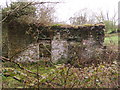
Building by drive to Fron-las
Derelict building, looks like it could have been agricultural as there are two doorways on this wall.
Image: © chris whitehouse
Taken: 27 Apr 2012
0.04 miles
2
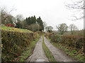
Heol fynedfa a llwybr / Access road and path
Heol fynedfa a llwybr troed cyhoeddus.
An access road and public footpath.
Image: © Alan Richards
Taken: 5 Feb 2024
0.08 miles
3
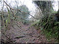
Llwybr wedi ei esgeuluso / A neglected path
Llwybr wedi ei esgeuluso yn arwain at gae. Yn anffodus, ar adeg ysgrifennu hwn mae'r llwybr wedi ei rwystro mewn salw man.
A neglected public footpath approaching a field. Unfortunately, at the time of writing the path is obstructed in several places.
Image: © Alan Richards
Taken: 5 Feb 2024
0.12 miles
5
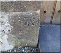
Ordnance Survey Cut Mark
This OS cut mark can be found on the east face of St Mary's Church. It marks a point 156.043m above mean sea level.
Image: © Adrian Dust
Taken: 3 Mar 2020
0.15 miles
6
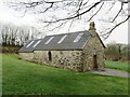
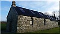
Eglwys Fair & Churig Church
Eglwys Fair & Churig, hen gapel anwes i Henllan Amgoed a fu'n eglwys blwyfol yn ddiweddarach. Dirywiodd cyflwr yr eglwys ac hyd at yn gymharol ddiweddar bu'n adfail di-do. Mae hi'n bellach yn eiddo preifat.
Eglwys Fair & Churig was a fomer chapel of ease belonging to Henllan Amgoed before becoming a parish church. The chapel fell into disrepair and was until quite recently a roofless ruin. It's now privately own.
Image: © Alan Richards
Taken: 5 Feb 2024
0.16 miles
7
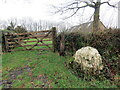
Garreg fawr ar bwys eglwys / A large stone by a church
Garreg hir gwyn o gwarts a leolir y tu fas i furiau Eglwys Fair & Churig.
A large quartz stone located outside the boundary wall of Eglwys Fair & Churig Church.
Image: © Alan Richards
Taken: 5 Feb 2024
0.16 miles
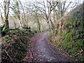
8

Llwybr yn agosau at ryd / Path nears a ford
Llwybr troed cyhoeddus yn mynd i gyfeiriad rhyd.
A public footpath heads in the direction of a ford.
Image: © Alan Richards
Taken: 7 Feb 2024
0.19 miles
9
Llwybr yn mynd i lawr y waered. / Path descends the hill
Llwybr troed cyhoeddus yn mynd i lawr y waered tuag at ryd.
A public footpath descends the hill towards a ford.
Image: © Alan Richards
Taken: 7 Feb 2024
0.22 miles
10
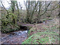
Pompren yn croesi nant / Footbridge crosses a stream
Pompren yn croesi nant ddinenw. Yn anffodus, ar adeg ysgrifennu hwn mae'r llwybr wedi ei rwystro mewn sawl man.
A footbridge crosses an unnamed stream. Unfortunately, at the time of writing the footpath is obstructed in several places.
Image: © Alan Richards
Taken: 5 Feb 2024
0.24 miles