IMAGES TAKEN NEAR TO
Llanpumsaint, CARMARTHEN, SA33 6LE
Introduction
This page details the photographs taken nearby to SA33 6LE by members of the Geograph project.
The Geograph project started in 2005 with the aim of publishing, organising and preserving representative images for every square kilometre of Great Britain, Ireland and the Isle of Man.

There are currently over 7.5m images from over14,400 individuals and you can help contribute to the project by visiting https://www.geograph.org.uk
Image Map
Images are licensed for reuse under creativecommons.org/licenses/by-sa/2.0
Notes
- Clicking on the map will re-center to the selected point.
- The higher the marker number, the further away the image location is from the centre of the postcode.
Image Listing (6 Images Found)
Images are licensed for reuse under creativecommons.org/licenses/by-sa/2.0
Image
Details
Distance
1
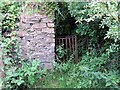
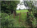
Llwybr Frongoch Path
Gât fochyn wrth ochr adfeilion anhedd-dy o'r enw Blaen Golau. Yswaeth, mae'r llwybr wedi ei rwystro ar ol degawdau of esgeuslustra.
A kissing gate at the ruined property known as Blaen Golau. Alas, the path is obstructed after decades of neglect.
Image: © Alan Richards
Taken: 23 Jul 2015
0.13 miles
2
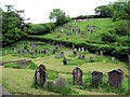
Mynwent Ffynnon Henri / Ffynnon Henri Burial Ground
Mynwent Capel Ffynnon Henri, addoldy'r Bedyddwyr sy'n ymestyn lan at y tyle tu hwnt.
Ffynnon Henri (trans. Henry's spring) Baptist Chapel's burial ground which stretches up to the hill beyond.
Image: © Alan Richards
Taken: 7 Jun 2014
0.18 miles
3
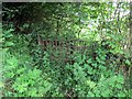
Llwybr Capel Ffynnon Henri Chapel Path
Llwybr cyhoeddus sy wedi ei rwystro gan dyfiant ym mynwent Capel Ffynnon Henri.
A public footpath obstructed by vegetation at Ffynnon Henri Baptist Chapel.
Image: © Alan Richards
Taken: 7 Jun 2014
0.20 miles
4
Isolated chapel
Will add details when I have uploaded other pics from here.
Image: © Jonathan Billinger
Taken: 15 Oct 2008
0.22 miles
5
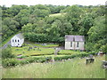
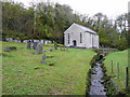
Capel Ffynnonhenri, Llanpumsaint
Golygfa o'r heol uwchben y fynwent / View from road above graveyard
Image: © David Jones
Taken: 19 Jul 2011
0.23 miles
6
Llwybr Cware / Cware path
Gât fochyn ar lwybr cyhoeddus ger Farm y Cware.
A kissing gate on a public footpath near Cware Farm < cwarau (trans. quarries).
Image: © Alan Richards
Taken: 23 Jul 2015
0.23 miles