IMAGES TAKEN NEAR TO
Bancyfelin, CARMARTHEN, SA33 5NS
Introduction
This page details the photographs taken nearby to SA33 5NS by members of the Geograph project.
The Geograph project started in 2005 with the aim of publishing, organising and preserving representative images for every square kilometre of Great Britain, Ireland and the Isle of Man.

There are currently over 7.5m images from over14,400 individuals and you can help contribute to the project by visiting https://www.geograph.org.uk
Image Map
Images are licensed for reuse under creativecommons.org/licenses/by-sa/2.0
Notes
- Clicking on the map will re-center to the selected point.
- The higher the marker number, the further away the image location is from the centre of the postcode.
Image Listing (6 Images Found)
Images are licensed for reuse under creativecommons.org/licenses/by-sa/2.0
Image
Details
Distance
1
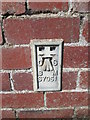
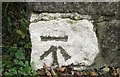
Ordnance Survey Flush Bracket (S7951)
This OS Flush Bracket can be found on a farm building at Castell-Y-Waun Farm. It marks a point 33.682m above mean sea level.
Image: © Adrian Dust
Taken: 6 Jul 2014
0.03 miles
2
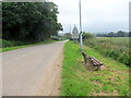
Heol i Fancyfelin / Road to Bancyfelin
Heol yn arwain at bentre Banyfelin. Cyn adeiladu'r ffordd ddeuol dyma oedd y brif heol i Gaerfyrddin.
A road heading towards the village of Bancyfelin (trans. mill bank). Prior to constructing the nearby duel carriageway this was the main road to Carmarthen.
Image: © Alan Richards
Taken: 18 Aug 2023
0.07 miles
3
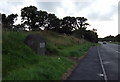
Lay-by near Bancyfelin
The plaque on the boulder commemorates the opening of this A40 dual-carriage extension east of Sancler/St Clears in 1995.
Image: © Natasha Ceridwen de Chroustchoff
Taken: 9 Sep 2008
0.14 miles
4
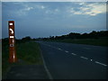
Lay-by on the A 40 near Bancyfelin
A view looking west along the A40 dual carriageway showing the lay-by and the emergency telephone box near Bancyfelin.
Image: © Martyn Harries
Taken: 5 May 2011
0.16 miles
5
Ordnance Survey Cut Mark
This OS cut mark can be found on the SE parapet of the bridge. It marks a point 18.791m above mean sea level.
Image: © Adrian Dust
Taken: 9 Oct 2016
0.19 miles
6
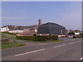
Werndale Private Hospital Bancyfelin
The front section of the building looks a bit strange (morbid) for a hospital, the section to the left was the Werndale Hotel many years ago. Drive at left of Hospital is to Wern Farm.
Image: © chris whitehouse
Taken: 2 Mar 2012
0.24 miles