IMAGES TAKEN NEAR TO
Llangynog, CARMARTHEN, SA33 5DJ
Introduction
This page details the photographs taken nearby to SA33 5DJ by members of the Geograph project.
The Geograph project started in 2005 with the aim of publishing, organising and preserving representative images for every square kilometre of Great Britain, Ireland and the Isle of Man.

There are currently over 7.5m images from over14,400 individuals and you can help contribute to the project by visiting https://www.geograph.org.uk
Image Map
Images are licensed for reuse under creativecommons.org/licenses/by-sa/2.0
Notes
- Clicking on the map will re-center to the selected point.
- The higher the marker number, the further away the image location is from the centre of the postcode.
Image Listing (6 Images Found)
Images are licensed for reuse under creativecommons.org/licenses/by-sa/2.0
Image
Details
Distance
1
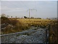
Power lines over rough grazing
A roadside field with frost lingering in the shade.
Image: © Peter Shaw
Taken: 2 Jan 2009
0.09 miles
2
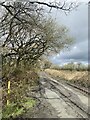
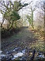
Muddy track
Public footpath leading to Cwmcoch.
Image: © Alan Hughes
Taken: 10 Apr 2023
0.10 miles
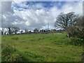
4
Llwybr ger Bryn-glas / Footpath near Bryn-glas
Llwybr cyhoeddus ger anheddiad o'r enw Bryn-glas.
A public footpath near a property known as Bryn-glas (trans. green hill).
Image: © Alan Richards
Taken: 12 Jul 2023
0.14 miles
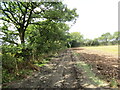
5
Frosty track
A track between two fields on a frosty January day.
Image: © Peter Shaw
Taken: 2 Jan 2009
0.15 miles
6
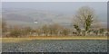
Field view
View over valley on a cold January day with the frost still lingering in the shade. Below and out of view are the main A40 west of Carmarthen and Cors-goch http://www.geograph.org.uk/photo/377864 .
Image: © Peter Shaw
Taken: 2 Jan 2009
0.21 miles