IMAGES TAKEN NEAR TO
Ger Y Capel, CARMARTHEN, SA33 5AQ
Introduction
This page details the photographs taken nearby to Ger Y Capel, SA33 5AQ by members of the Geograph project.
The Geograph project started in 2005 with the aim of publishing, organising and preserving representative images for every square kilometre of Great Britain, Ireland and the Isle of Man.

There are currently over 7.5m images from over14,400 individuals and you can help contribute to the project by visiting https://www.geograph.org.uk
Image Map
Images are licensed for reuse under creativecommons.org/licenses/by-sa/2.0
Notes
- Clicking on the map will re-center to the selected point.
- The higher the marker number, the further away the image location is from the centre of the postcode.
Image Listing (11 Images Found)
Images are licensed for reuse under creativecommons.org/licenses/by-sa/2.0
Image
Details
Distance
1
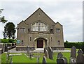
Llangain Chapel
Smyrna Welsh Independent Chapel.
Image: © Ian Rob
Taken: 29 Jun 2021
0.05 miles
2
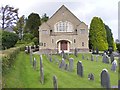
Llangain Chapel
The Smyrna chapel off the B4312 in Llangain village.
Image: © Gordon Griffiths
Taken: 23 Sep 2011
0.05 miles
3
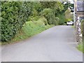
Chapel Lane
The lane Heol Smyrna in Llangain.
Image: © Gordon Griffiths
Taken: 23 Sep 2011
0.05 miles
5
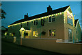
Tafarn Pant y Dderwen at Llangain near Carmarthen
This was taken at one minute past eleven o'clock at night after a bright sunny day at the end of May. This is the only pub in the village of church, chapel, memorial hall, primary school and a part time post office and shop.
Image: © Gwilym Thomas
Taken: 27 May 2008
0.12 miles
6
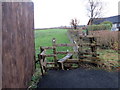
Llwybr Llangain / Llangain path
Llwybr cyhoeddus yn arwain at Heol y Llan.
A public footpath heading towards Heol y Llan (trans. church road).
Image: © Alan Richards
Taken: 11 Dec 2019
0.18 miles
7
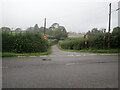
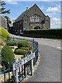
Minor road near Llangain
It runs from the B4312 to Heol Smyrna
Image: © Eirian Evans
Taken: 22 Sep 2022
0.20 miles
8
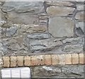
Ordnance Survey Cut Mark
This OS cut mark can be found on the old school building which is now a house. It marks a point 108.640m above mean sea level.
Image: © Adrian Dust
Taken: 1 May 2017
0.22 miles
9
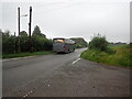
School bus on the B4312
Heading towards Carmarthen
Image: © Eirian Evans
Taken: 22 Sep 2022
0.22 miles
10
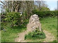
Cerrig Myrddin / Merlin's Quoits
Y maenhir hwn ynghyd a charreg arall gerllaw (wedi ei chuddio'n rhannol y tu ol i lwynyn) yw'r unig beth syn weddill o gromlech o'r Oes Neolithig (tua 3000 CC). Gelwir y meinihirion hyn yn 'Cerrig Myrddin' oherwydd, yn ol y chwedl, roedd Myrddin, y dewin pwerus, yn hoff iawn o chwarare coets gyda nhw.
The standing stone is one of a pair (the other is partially hidden behind a bush) which are in fact the remnants of a Neolithic Cromlech built around 3000 BC. Centuries later the stones became linked with the legendary wizard, Merlin, who used them as quoits hence its English name.
Image: © Alan Richards
Taken: 2 May 2011
0.22 miles